IMAGES TAKEN NEAR TO
St. James Lane, LONDON, N10 3DA
Introduction
This page details the photographs taken nearby to St. James Lane, N10 3DA by members of the Geograph project.
The Geograph project started in 2005 with the aim of publishing, organising and preserving representative images for every square kilometre of Great Britain, Ireland and the Isle of Man.

There are currently over 7.5m images from over14,400 individuals and you can help contribute to the project by visiting https://www.geograph.org.uk
Image Map
Images are licensed for reuse under creativecommons.org/licenses/by-sa/2.0
Notes
- Clicking on the map will re-center to the selected point.
- The higher the marker number, the further away the image location is from the centre of the postcode.
Image Listing (229 Images Found)
Images are licensed for reuse under creativecommons.org/licenses/by-sa/2.0
Image
Details
Distance
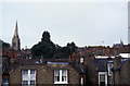
2
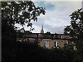
View of Highgate Village from Parkland Walk North
Parkland Walk is a nature trail, designated as a nature reserve in 1990, following the route of a railway line which used to run from Highgate to Alexandra Palace. The line closed in 1982. This view of Highgate Village was taken from the northern end of Parkland Walk, which starts at Cranley Gardens and leads into Alexandra Park, looking west-northwest.
Image: © Robert Lamb
Taken: 26 Sep 2010
0.03 miles
3
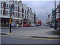
Muswell Hill Broadway
From St James Lane corner
Image: © David Howard
Taken: 6 Jun 2008
0.04 miles
4
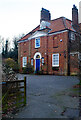
Muswell Hill : vicarage, St James's Church
Grade II listed building from 1915 (architect W.E.V. Crompton). Description at this https://historicengland.org.uk/listing/the-list/list-entry/1390824.
Image: © Jim Osley
Taken: 1 Jan 2021
0.04 miles
5
View of the church on Muswell Hill Road from Parkland Walk North
Looking northwest. The fencing in the foreground will date back to when the path was a railway line pre-1982.
Image: © Robert Lamb
Taken: 26 Sep 2010
0.04 miles
6

Church of St James, Muswell Hill
Built between 1900 and 1910 to the designs of architect J. S. Alder. Grade II listed building described at this https://historicengland.org.uk/listing/the-list/list-entry/1358863. There are numerous other examples of ecclesiastical work by Alder in the London area.
Image: © Jim Osley
Taken: 29 Dec 2015
0.05 miles
7
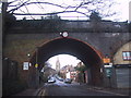
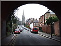
St james's Lane through the old viaduct
Image: © Sarah Charlesworth
Taken: 12 Jan 2014
0.05 miles
8
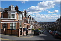
Hillfield Park
A steeply graded side road off Muswell Hill Broadway with a view over the east end of London including Stratford.
Image: © Martin Addison
Taken: 22 Mar 2014
0.05 miles
9
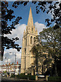
St James, Muswell Hill
At the junction of Muswell Hill Road and Fortis Green Road, the original church of St James was built in 1842. In 1900 the original church was demolished and work on the current one commenced. The church is situated on top of a hill and its 170ft spire, which was finally completed in 1910, is visible for miles around. The church was damaged by incendiary bombs in 1941. The subsequent rebuild was completed in 1952. The church was designed by the prolific church architect John Samuel Alder (1848-1919).
Image: © Martin Addison
Taken: 14 Sep 2006
0.05 miles
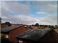
10
View of Muswell Hill
Taken from the old railway line, now renamed the Parkland Walk.
Image: © Chris Heaton
Taken: 7 Sep 2003
0.05 miles