IMAGES TAKEN NEAR TO
Dukes Avenue, LONDON, N10 2QD
Introduction
This page details the photographs taken nearby to Dukes Avenue, N10 2QD by members of the Geograph project.
The Geograph project started in 2005 with the aim of publishing, organising and preserving representative images for every square kilometre of Great Britain, Ireland and the Isle of Man.

There are currently over 7.5m images from over14,400 individuals and you can help contribute to the project by visiting https://www.geograph.org.uk
Image Map
Images are licensed for reuse under creativecommons.org/licenses/by-sa/2.0
Notes
- Clicking on the map will re-center to the selected point.
- The higher the marker number, the further away the image location is from the centre of the postcode.
Image Listing (287 Images Found)
Images are licensed for reuse under creativecommons.org/licenses/by-sa/2.0
Image
Details
Distance
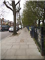
1
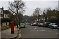
Looking along Dukes Avenue towards Muswell Hill
Image: © Christopher Hilton
Taken: 9 Feb 2017
0.03 miles
2
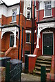
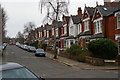
Victorian houses on Dukes Avenue
This terrace of houses takes the form, effectively, of semi-detached houses linked by a small recessed triangular bay. In each bay, doors lead into each house at basement level, below the handsome front door: the lower doors presumably gave into a downstairs kitchen and were the route in for tradesmen's deliveries.
Image: © Christopher Hilton
Taken: 9 Feb 2017
0.04 miles
3
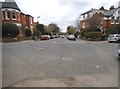
Dukes Avenue at the junction of Grove Avenue
These are the typical Edwardian houses which occupy the majority of Muswell Hill
Image: © David Howard
Taken: 17 Apr 2018
0.08 miles
5
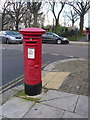
Muswell Hill: postbox № N10 21, Duke?s Avenue
An Edward VII-reign box on the corner of The Avenue (background) which is the scene of minor traffic problems just now as cars parked both sides make it awkward for everyone to pass.
Image: © Chris Downer
Taken: 19 Jan 2014
0.08 miles
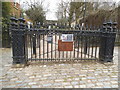
7
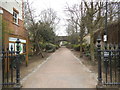
The north entrance to Alexandra Park
One of the few remnants of the closed railway is ahead on the bridge.
Image: © David Howard
Taken: 17 Apr 2018
0.09 miles
8
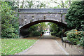
Disused Railway Bridge, Alexandra Park
This bridge used to carry the Alexandra Palace Branch of the Great northern Railway to its terminus beside the palace. Built by the Muswell Hill Railway, the line opened in 1873 at the same time as the palace. Passenger services ceased in 1954. There are a number of sources on the internet describing the history and route of this branch line.
The road beyond the bridge is Grove Avenue.
Image: © Martin Addison
Taken: 28 Oct 2010
0.09 miles
10

Grove Avenue in the snow
Looking down Grove Avenue from near the entrance to Alexandra Park. The snow was the result of falls on the 8th and 11th December and at this time showed no sign of thawing, with snow remaining on the ground until Christmas.
Image: © E Gammie
Taken: 12 Dec 1981
0.09 miles