IMAGES TAKEN NEAR TO
Rosebery Road, LONDON, N10 2LJ
Introduction
This page details the photographs taken nearby to Rosebery Road, N10 2LJ by members of the Geograph project.
The Geograph project started in 2005 with the aim of publishing, organising and preserving representative images for every square kilometre of Great Britain, Ireland and the Isle of Man.

There are currently over 7.5m images from over14,400 individuals and you can help contribute to the project by visiting https://www.geograph.org.uk
Image Map
Images are licensed for reuse under creativecommons.org/licenses/by-sa/2.0
Notes
- Clicking on the map will re-center to the selected point.
- The higher the marker number, the further away the image location is from the centre of the postcode.
Image Listing (113 Images Found)
Images are licensed for reuse under creativecommons.org/licenses/by-sa/2.0
Image
Details
Distance
1
Donovan Avenue N10
At the junction with Rosebery Road
Image: © Robin Sones
Taken: 23 Nov 2011
0.09 miles
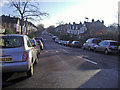
2
Curzon Road N10
From the junction with Muswell Road
Image: © Robin Sones
Taken: 23 Nov 2011
0.10 miles
3
Muswell Hill : Borough boundary markers
Where the Borough of Hornsey met the Borough of Wood Green.
Image: © Jim Osley
Taken: 5 Dec 2020
0.12 miles
4

Grove Avenue in the snow
Looking down Grove Avenue from near the entrance to Alexandra Park. The snow was the result of falls on the 8th and 11th December and at this time showed no sign of thawing, with snow remaining on the ground until Christmas.
Image: © E Gammie
Taken: 12 Dec 1981
0.13 miles
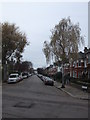
6
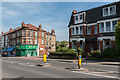
Alexandra Park Road, Muswell Hill, London N10
Looking across towards Rosebery Road.
Image: © Christine Matthews
Taken: 4 May 2014
0.14 miles
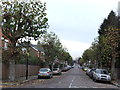
7
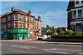
Alexandra Park Road, Muswell Hill, London N10
Looking across towards Rosebery Road. Alexander Palace can be seen on the horizon between the buildings.
Image: © Christine Matthews
Taken: 4 May 2014
0.14 miles
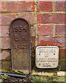
8
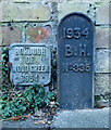
Muswell Hill : borough boundary markers
B.H. stands for Borough of Hornsey.
Image: © Jim Osley
Taken: 4 Dec 2020
0.15 miles
9
Muswell Road N10
At the junction of Methuen Park
Image: © Robin Sones
Taken: 23 Nov 2011
0.15 miles
10
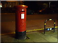
Muswell Hill: postbox № N10 22, Alexandra Park Road
A large George V-reign postbox outside the former post office (see Image).
Image: © Chris Downer
Taken: 19 Jan 2014
0.16 miles