IMAGES TAKEN NEAR TO
Osier Crescent, LONDON, N10 1RD
Introduction
This page details the photographs taken nearby to Osier Crescent, N10 1RD by members of the Geograph project.
The Geograph project started in 2005 with the aim of publishing, organising and preserving representative images for every square kilometre of Great Britain, Ireland and the Isle of Man.

There are currently over 7.5m images from over14,400 individuals and you can help contribute to the project by visiting https://www.geograph.org.uk
Image Map (Loading...)


Getting Data...Please wait
Leaflet Map data © OpenStreetMap
Images are licensed for reuse under creativecommons.org/licenses/by-sa/2.0
Notes
- Clicking on the map will re-center to the selected point.
- The higher the marker number, the further away the image location is from the centre of the postcode.
Image Listing (28 Images Found)
Images are licensed for reuse under creativecommons.org/licenses/by-sa/2.0
Image
Details
Distance
2
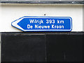
A Little Piece of Belgium
Souvenir of annual visits to the Paastornoi by Crouch End Vampires FC, as guests of FC Rood-Wit Wilrijk - an amateur club in Antwerp, Belgium. See the Crouch End Vampires website for their history.
Image: © Martin Addison
Taken: 14 Sep 2006
0.08 miles
3

Crouch End Vampires
No need for garlic and holy water! This is the clubhouse of Crouch End Vampires Football Club, members of the Southern Amateur Football League. They play their matches on Muswell Hill Sports Ground. A history of the club can be found on their website.
Image: © Martin Addison
Taken: 14 Sep 2006
0.08 miles
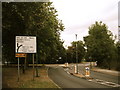
4
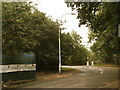
Towards Trott Road and Coppetts Road roundabout
Image: © Chris Whippet
Taken: 5 Aug 2008
0.11 miles
5
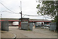
Lynx Depot
Entrance to the Lynx depot on Coppetts Road. This is a good site for a distribution depot - with easy access both east and west on the adjacent A406 North Circular Road.
The depot was closed the same year, indeed the sale to George Wimpey had been agreed by June - before this photo was taken. The planning permission was for a mix of residential and industrial development.
Image: © Martin Addison
Taken: 14 Sep 2006
0.12 miles
9
Corner of Barrenger Road and Marriott Road, Coppetts Wood
Image: © Chris Whippet
Taken: 7 Jan 2009
0.15 miles
10
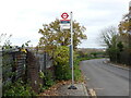
Trott Lane Bus Stop
What seems like a lonely country bus stop is in fact just inside the North Circular Road North London. Trott Road was built in the 1970s to take local traffic off the North Circular Road. To the left of the bus stop on the horizon is the tower for the Friern Barnet Asylum, naturally now converted into luxury flats.
Image: © John Kingdon
Taken: 17 Nov 2020
0.16 miles