IMAGES TAKEN NEAR TO
Greenham Road, LONDON, N10 1LP
Introduction
This page details the photographs taken nearby to Greenham Road, N10 1LP by members of the Geograph project.
The Geograph project started in 2005 with the aim of publishing, organising and preserving representative images for every square kilometre of Great Britain, Ireland and the Isle of Man.

There are currently over 7.5m images from over14,400 individuals and you can help contribute to the project by visiting https://www.geograph.org.uk
Image Map
Images are licensed for reuse under creativecommons.org/licenses/by-sa/2.0
Notes
- Clicking on the map will re-center to the selected point.
- The higher the marker number, the further away the image location is from the centre of the postcode.
Image Listing (72 Images Found)
Images are licensed for reuse under creativecommons.org/licenses/by-sa/2.0
Image
Details
Distance

7
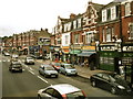
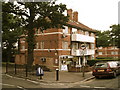
Colney Hatch Shops
Keenan's, the pub on the right, was until recently known as "Spoons" and was the site of the first Wetherspoons pub in 1979.
Image: © Chris Whippet
Taken: 5 Aug 2008
0.12 miles