IMAGES TAKEN NEAR TO
Bedford Close, LONDON, N10 1BB
Introduction
This page details the photographs taken nearby to Bedford Close, N10 1BB by members of the Geograph project.
The Geograph project started in 2005 with the aim of publishing, organising and preserving representative images for every square kilometre of Great Britain, Ireland and the Isle of Man.

There are currently over 7.5m images from over14,400 individuals and you can help contribute to the project by visiting https://www.geograph.org.uk
Image Map (Loading...)


Getting Data...Please wait
Leaflet Map data © OpenStreetMap
Images are licensed for reuse under creativecommons.org/licenses/by-sa/2.0
Notes
- Clicking on the map will re-center to the selected point.
- The higher the marker number, the further away the image location is from the centre of the postcode.
Image Listing (93 Images Found)
Images are licensed for reuse under creativecommons.org/licenses/by-sa/2.0
Image
Details
Distance
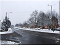
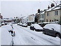
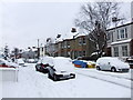
2
Pembroke Road
Pembroke Road looking North, with spire of Christchurch,Southgate, visible in the distance
Image: © Roland Francois Lack
Taken: 9 May 2011
0.05 miles
7
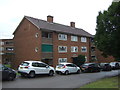
Kingsfield House
Flats off Colney Hatch Lane.
Image: © JThomas
Taken: 27 Jul 2019
0.07 miles
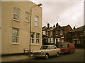
10

St Peter le Poer, Colney Hatch Lane, London N10 - Font
Image: © John Salmon
Taken: 20 Sep 2003
0.08 miles