IMAGES TAKEN NEAR TO
Murray Drive, LARKHALL, ML9 3NB
Introduction
This page details the photographs taken nearby to Murray Drive, ML9 3NB by members of the Geograph project.
The Geograph project started in 2005 with the aim of publishing, organising and preserving representative images for every square kilometre of Great Britain, Ireland and the Isle of Man.

There are currently over 7.5m images from over14,400 individuals and you can help contribute to the project by visiting https://www.geograph.org.uk
Image Map
Images are licensed for reuse under creativecommons.org/licenses/by-sa/2.0
Notes
- Clicking on the map will re-center to the selected point.
- The higher the marker number, the further away the image location is from the centre of the postcode.
Image Listing (14 Images Found)
Images are licensed for reuse under creativecommons.org/licenses/by-sa/2.0
Image
Details
Distance
1
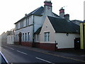
Stonehouse Institute
Stonehouse Institute was built in the early 1900's and is situated on New Street about 50 metres away from the cross. The hall comprises a main hall, meeting room, two small committee rooms, kitchen and toilets. There is also a lesser hall upstairs.
Image: © Paul Nardone
Taken: Unknown
0.11 miles
2
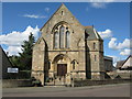
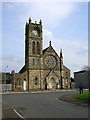
Stonehouse Congregational United Reformed Church
On Johnstone Drive, Stonehouse.
Image: © G Laird
Taken: 27 Aug 2010
0.11 miles

6
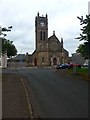
Paterson United Free Church of Scotland, Stonehouse
Image: © Iain Thompson
Taken: 6 May 2006
0.20 miles
7
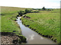
Watstone Burn
Just outside Stonehouse, the Watstone Burn is a tributary of the Cander Water.
Image: © G Laird
Taken: 16 Aug 2013
0.20 miles
8
Stonehouse, Paterson United Free Church of Scotland
Image: © Robert Murray
Taken: 17 Oct 2015
0.22 miles
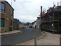
9
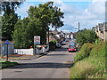
Union Street, Stonehouse
Near the sites of the old gas works and a brick and tile works. The railing on the left enclose the main electrical sub-station for the area.
Image: © wrobison
Taken: 30 Jun 2020
0.23 miles
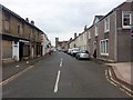
10
Park, King Street
An open space in Stonehouse with Galloway and Macleod, a feed merchant in the background.
Image: © Richard Webb
Taken: 21 Apr 2014
0.23 miles