IMAGES TAKEN NEAR TO
Fiveways Road, LARKHALL, ML9 3BU
Introduction
This page details the photographs taken nearby to Fiveways Road, ML9 3BU by members of the Geograph project.
The Geograph project started in 2005 with the aim of publishing, organising and preserving representative images for every square kilometre of Great Britain, Ireland and the Isle of Man.

There are currently over 7.5m images from over14,400 individuals and you can help contribute to the project by visiting https://www.geograph.org.uk
Image Map
Images are licensed for reuse under creativecommons.org/licenses/by-sa/2.0
Notes
- Clicking on the map will re-center to the selected point.
- The higher the marker number, the further away the image location is from the centre of the postcode.
Image Listing (7 Images Found)
Images are licensed for reuse under creativecommons.org/licenses/by-sa/2.0
Image
Details
Distance
1
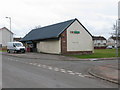
Netherburn Post Office
On Fiveways Road, Netherburn.
Image: © G Laird
Taken: 29 Mar 2010
0.03 miles
2
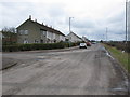
Entering Netherburn from the East
Looking along Overton Road.
Image: © G Laird
Taken: 29 Mar 2010
0.08 miles
3
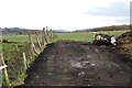
Field entrance and midden
A way into a field above the Clyde.
Image: © Richard Webb
Taken: 4 Mar 2012
0.17 miles
4
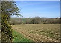
Stubble field near Netherburn
Farmland sloping down to the Clyde, viewed from a path leading down to Overton Brae. The whins by the edge of the path are beginning to bloom, but haven't yet reached their full yellow intensity.
Image: © Alan O'Dowd
Taken: 13 Apr 2020
0.18 miles
5
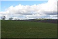
Grass, West High Overton
A grass field on the plateau above Clydesdale.
Image: © Richard Webb
Taken: 4 Mar 2012
0.19 miles
6
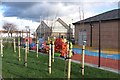
Nursery, Netherburn
A colourful playground with a shop and post office facade.
Image: © Richard Webb
Taken: 4 Mar 2012
0.20 miles
7
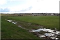
Field, Netherburn
Soon after this was taken, this became a building site.
Image: © Richard Webb
Taken: 4 Mar 2012
0.23 miles