IMAGES TAKEN NEAR TO
Corramill Road, CARLUKE, ML8 5QW
Introduction
This page details the photographs taken nearby to Corramill Road, ML8 5QW by members of the Geograph project.
The Geograph project started in 2005 with the aim of publishing, organising and preserving representative images for every square kilometre of Great Britain, Ireland and the Isle of Man.

There are currently over 7.5m images from over14,400 individuals and you can help contribute to the project by visiting https://www.geograph.org.uk
Image Map
Images are licensed for reuse under creativecommons.org/licenses/by-sa/2.0
Notes
- Clicking on the map will re-center to the selected point.
- The higher the marker number, the further away the image location is from the centre of the postcode.
Image Listing (5 Images Found)
Images are licensed for reuse under creativecommons.org/licenses/by-sa/2.0
Image
Details
Distance

2
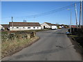
Road Junction near Crossford
The road straight on leads to Crossford while the road branching off to the left leads to Tillietudlem and Craignethan Castle.
Image: © G Laird
Taken: 29 Mar 2009
0.04 miles
3
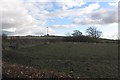
Inside the road junction
A field where Corra Mill Road and Blair Road meet.
Image: © Richard Webb
Taken: 4 Mar 2012
0.05 miles
4
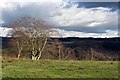
Edge of the plateau
Beyond the wind sculpted beech at Blair, the ground falls sharply to the deep valley containing the Clyde.
Image: © Richard Webb
Taken: 4 Mar 2012
0.09 miles
5
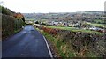
Descending to Crossford
Crossford itself lies down to the right beside the Clyde.
Image: © Gordon Brown
Taken: 24 Oct 2020
0.20 miles