IMAGES TAKEN NEAR TO
Lilliesleaf Drive, AIRDRIE, ML6 8XF
Introduction
This page details the photographs taken nearby to Lilliesleaf Drive, ML6 8XF by members of the Geograph project.
The Geograph project started in 2005 with the aim of publishing, organising and preserving representative images for every square kilometre of Great Britain, Ireland and the Isle of Man.

There are currently over 7.5m images from over14,400 individuals and you can help contribute to the project by visiting https://www.geograph.org.uk
Image Map
Images are licensed for reuse under creativecommons.org/licenses/by-sa/2.0
Notes
- Clicking on the map will re-center to the selected point.
- The higher the marker number, the further away the image location is from the centre of the postcode.
Image Listing (7 Images Found)
Images are licensed for reuse under creativecommons.org/licenses/by-sa/2.0
Image
Details
Distance
1
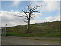
Dead tree on Lancaster Avenue
Rough ground here near Chapelhall, but new housing all around, just off the M8.
Image: © M J Richardson
Taken: 14 Apr 2012
0.12 miles
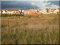
2
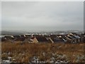
Chapelhall, from waste ground to the south
Looking west across the southern portion of the village.
Image: © Stephen Sweeney
Taken: 3 Dec 2012
0.13 miles
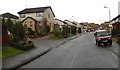
3
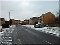
Tarbolton Crescent, Chapelhall
New housing estate on the outskirts of the village.
Image: © Stephen Sweeney
Taken: 3 Dec 2012
0.16 miles
4
Rockcliffe Path
New housing, Chapelhall.
Image: © Richard Webb
Taken: 4 Oct 2009
0.23 miles
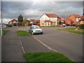
5
New houses and undeveloped land, Chapelhall
Looking across land awaiting development seen from the back of the Organon, now Schering-Plough building on York Road.
Image: © Richard Webb
Taken: 4 Oct 2009
0.23 miles
6
Callander Road
Residential area next to the Schering-Plough factory.
Image: © Richard Webb
Taken: 22 Jan 2010
0.24 miles
7
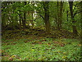
Ruins of Lauchope House
Local tradition has it that the Laird of Muirhead was granted the lands of Lauchope
for ridding the area of the 'robber giant' Bertram Shotts.
Image: © Jim Smillie
Taken: 7 May 2009
0.25 miles