IMAGES TAKEN NEAR TO
Arbuckle Road, AIRDRIE, ML6 7WF
Introduction
This page details the photographs taken nearby to Arbuckle Road, ML6 7WF by members of the Geograph project.
The Geograph project started in 2005 with the aim of publishing, organising and preserving representative images for every square kilometre of Great Britain, Ireland and the Isle of Man.

There are currently over 7.5m images from over14,400 individuals and you can help contribute to the project by visiting https://www.geograph.org.uk
Image Map
Images are licensed for reuse under creativecommons.org/licenses/by-sa/2.0
Notes
- Clicking on the map will re-center to the selected point.
- The higher the marker number, the further away the image location is from the centre of the postcode.
Image Listing (37 Images Found)
Images are licensed for reuse under creativecommons.org/licenses/by-sa/2.0
Image
Details
Distance
1
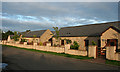
West Arbuckle
Smart cottages by the end of the public road.
Image: © Anne Burgess
Taken: 24 Aug 2013
0.00 miles
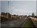
2
Road to Stanrigg Memorial
Pedestrian access on the left
Compare Image
Image: © Jim Smillie
Taken: 14 Jul 2021
0.02 miles
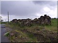
3
West Arbuckle
The ruined building is of some considerable age, because it is marked on the mid-Victorian six-inch Ordnance Survey Map. However it is unclear whether it was a house or a farm building.
Image: © Anne Burgess
Taken: 24 Aug 2013
0.02 miles
4
West Arbuckle, ruins
On the north side of the road to Midtown these would have been colliery houses.
West Arbuckle is the last of the three Arbuckle(s) still named such. The other two have long since been renamed since first, William Roy's survey of 1752, and William Forrest in 1816 listed Midtown as Arbuckle and Easterton as East Arbuckle.
Image: © Robert Murray
Taken: 11 Jun 2011
0.02 miles
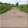
5
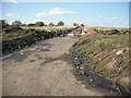
Closed road, West Arbuckle
A minor road, closed because further along it has been replaced by a deep hole, the site of opencast coal mining. The bike, horse and pedestrian friendly gate suggests a through route, and investigation found a fine single track path crossing to Darngavil Road.
Image: © Richard Webb
Taken: 16 Sep 2009
0.04 miles
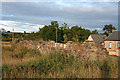
6
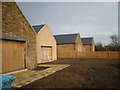
Restored West Arbuckle Steadings near Plains
Image: © Sarah McGuire
Taken: 30 Jan 2009
0.05 miles
7
Ruined Cottages in West Arbuckle
The road to the Memorial to Stanrigg pit disaster is to the left of ruin. These are to be incorporated into new development.
Image: © Sarah McGuire
Taken: 30 Jan 2009
0.06 miles
8
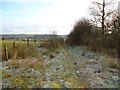
Arden to Barblues Track
A now redundant path - one of many that were used by colliers to move to and from work. Now cut off at the North Calder. See Image
Image: © Robert Murray
Taken: 2 Feb 2012
0.06 miles
9
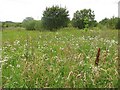
Flowers, West Arbuckle
Wildflowers on rough ground and colliery waste.
Image: © Richard Webb
Taken: 17 Aug 2010
0.06 miles
10
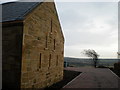
Restored West Arbuckle Steading near Plains
Site of old Burbluie Colliery Pit No.8. The hole area was riddled with pits up until the early 1900s. In the late 1900s it was then open cast mined and has now been restored to farmland or for building.
Image: © Sarah McGuire
Taken: 30 Jan 2009
0.06 miles