IMAGES TAKEN NEAR TO
Rydenmains Road, AIRDRIE, ML6 0NU
Introduction
This page details the photographs taken nearby to Rydenmains Road, ML6 0NU by members of the Geograph project.
The Geograph project started in 2005 with the aim of publishing, organising and preserving representative images for every square kilometre of Great Britain, Ireland and the Isle of Man.

There are currently over 7.5m images from over14,400 individuals and you can help contribute to the project by visiting https://www.geograph.org.uk
Image Map
Images are licensed for reuse under creativecommons.org/licenses/by-sa/2.0
Notes
- Clicking on the map will re-center to the selected point.
- The higher the marker number, the further away the image location is from the centre of the postcode.
Image Listing (29 Images Found)
Images are licensed for reuse under creativecommons.org/licenses/by-sa/2.0
Image
Details
Distance
1
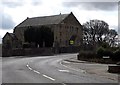
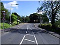
A scene at Glenmavis in North Lanarkshire
As a village road heads past the old kirk and kirkyard.
Image: © James Denham
Taken: 20 Apr 2013
0.11 miles
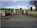
3

Glenmavis Cemetery
This vast cemetery extends northwards from the original New Monkland parish kirkyard at Glenmavis.
Image: © Anne Burgess
Taken: 24 Aug 2013
0.14 miles
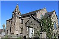
4
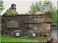
Watch House, New Monkland Church
At the gates of New Monkland Parish Church.
Legend has it that night watchmen kept guard against bodysnatchers from here.
The chimney is still intact but unfortunately the roof is not.
The roof has now been replaced www.geograph.org.uk/photo/1951526
Image: © Texas Radio and The Big Beat
Taken: 24 May 2009
0.14 miles
5
Watch House, New Monkland Church
Recently re-roofed and looking splendid.
Compare to picture from May 2009 www.geograph.org.uk/photo/1602708
Image: © Texas Radio and The Big Beat
Taken: 7 Jul 2010
0.14 miles
6
Glenmavis, Coatbridge Road
View uphill towards New Monkland Kirk (circa. 1650) mostly hidden behind the Beech trees. See RCAHMS record http://canmore.rcahms.gov.uk/en/site/45754/details/new+monkland+condorrat+road+parish+church/
Image: © Robert Murray
Taken: 26 Jul 2011
0.14 miles
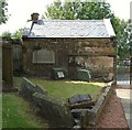
7
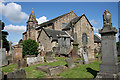
New Monkland Parish Kirk
The kirk and kirkyard are at Glenmavis, a mile or so from Airdrie. Originally built in about 1650, a single-storey building with a short steeple, the kirk was heightened in 1777, making the old steeple look a bit odd. Or was it? The Royal Commission on the Ancient and Historic Monuments of Scotland questions the alleged antiquity of the steeple, saying that its construction is similar to the rest of the 1777 stonework. Its stone used to be blackened by pollution from local heavy industry, earning it the nickname, 'The Auld Grey Kirk on the hill' but with the improvement in air quality the sandstone is reverting to a more natural colour.
Image: © Anne Burgess
Taken: 10 Jul 2014
0.14 miles
8
New housing on site of Kirkstyle Inn
Image: © Jim Smillie
Taken: 11 Feb 2023
0.15 miles
9
New Monkland Parish Church, Glenmavis
Founded c1640
Image: © Leslie Barrie
Taken: 23 May 2015
0.15 miles
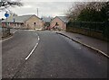
10
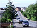
Glenmavis, Coatbridge Road
View downhill towards the centre of the village.
Image: © Robert Murray
Taken: 26 Jul 2011
0.15 miles