IMAGES TAKEN NEAR TO
Udston Terrace, HAMILTON, ML3 9HU
Introduction
This page details the photographs taken nearby to Udston Terrace, ML3 9HU by members of the Geograph project.
The Geograph project started in 2005 with the aim of publishing, organising and preserving representative images for every square kilometre of Great Britain, Ireland and the Isle of Man.

There are currently over 7.5m images from over14,400 individuals and you can help contribute to the project by visiting https://www.geograph.org.uk
Image Map
Images are licensed for reuse under creativecommons.org/licenses/by-sa/2.0
Notes
- Clicking on the map will re-center to the selected point.
- The higher the marker number, the further away the image location is from the centre of the postcode.
Image Listing (8 Images Found)
Images are licensed for reuse under creativecommons.org/licenses/by-sa/2.0
Image
Details
Distance
1
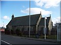
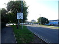
Burnbank Parish Church
Burbank village was incorporated into the Burgh of Hamilton in 1878. A Mission established a worship group in The Coffee Shop until the Chapel of Ease, dedicated in September 1880, was built. It was formed into a Parish Church in 1892. It was linked with Hamilton North Church in the 1980s
Image: © Elliott Simpson
Taken: 28 Mar 2009
0.05 miles
2
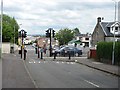
Glenlee Street
The junction with High Blantyre Road has been blocked off on either side.
Image: © Richard Webb
Taken: 20 Jun 2011
0.09 miles
3
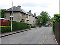
Thorntree Avenue
Residential street off Glenlee Street.
Image: © Richard Webb
Taken: 20 Jun 2011
0.10 miles
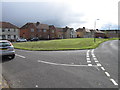
6
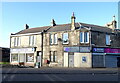
Businesses on Glasgow Road (A724), Hamilton
Image: © JThomas
Taken: 16 Sep 2021
0.22 miles
7
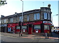
The Empire Bar, Hamilton
On Glasgow Road (A724).
Image: © JThomas
Taken: 16 Sep 2021
0.24 miles
8
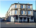
The Glenlee Bar, Hamilton
On Glasgow Road (A724).
Image: © JThomas
Taken: 16 Sep 2021
0.25 miles