IMAGES TAKEN NEAR TO
Park Place, BIGGAR, ML12 6BT
Introduction
This page details the photographs taken nearby to Park Place, ML12 6BT by members of the Geograph project.
The Geograph project started in 2005 with the aim of publishing, organising and preserving representative images for every square kilometre of Great Britain, Ireland and the Isle of Man.

There are currently over 7.5m images from over14,400 individuals and you can help contribute to the project by visiting https://www.geograph.org.uk
Image Map
Images are licensed for reuse under creativecommons.org/licenses/by-sa/2.0
Notes
- Clicking on the map will re-center to the selected point.
- The higher the marker number, the further away the image location is from the centre of the postcode.
Image Listing (243 Images Found)
Images are licensed for reuse under creativecommons.org/licenses/by-sa/2.0
Image
Details
Distance
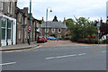
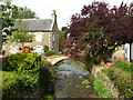
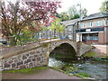
3
Footbridge over Biggar Burn, Biggar
Beside the main road (A702) through Biggar at the point where High Street becomes Coulter Road,
Image: © G Laird
Taken: 1 Jul 2017
0.01 miles
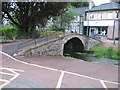
5
Cadger's brig, Biggar
William Wallace is said to have crossed this bridge in 1297.
Image: © adam sommerville
Taken: 13 Sep 2009
0.01 miles
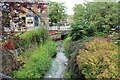
6
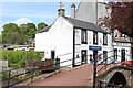
Cadger's Brig and Cross Keys, Biggar
Footbridge over Biggar Burn
Image: © Leslie Barrie
Taken: 30 May 2015
0.01 miles
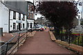
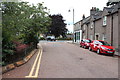
10
Bridge, Biggar
Crossing a burn by Gas Works Road and leading to Park Place. This took me 20 minutes to locate.
Image: © Chris Allen
Taken: 16 Oct 2010
0.01 miles