IMAGES TAKEN NEAR TO
High Street, BIGGAR, ML12 6BJ
Introduction
This page details the photographs taken nearby to High Street, ML12 6BJ by members of the Geograph project.
The Geograph project started in 2005 with the aim of publishing, organising and preserving representative images for every square kilometre of Great Britain, Ireland and the Isle of Man.

There are currently over 7.5m images from over14,400 individuals and you can help contribute to the project by visiting https://www.geograph.org.uk
Image Map (Loading...)


Getting Data...Please wait
Leaflet Map data © OpenStreetMap
Images are licensed for reuse under creativecommons.org/licenses/by-sa/2.0
Notes
- Clicking on the map will re-center to the selected point.
- The higher the marker number, the further away the image location is from the centre of the postcode.
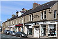
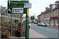
Image Listing (338 Images Found)
Images are licensed for reuse under creativecommons.org/licenses/by-sa/2.0
Image
Details
Distance
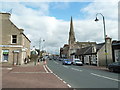
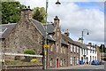
3
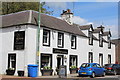
The Barony Restaurant, High Street, Biggar
Image: © Leslie Barrie
Taken: 30 May 2015
0.03 miles
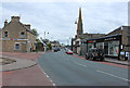
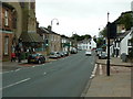
10
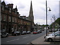
High Street, Biggar
The view of the Gillespie Centre in Biggar. The former church building (presumably Gillespie or Gillespie Memorial Church) is now a community centre operated in conjunction with Biggar Kirk, the parish church.
Image: © Sandy Gemmill
Taken: 19 May 2008
0.04 miles