IMAGES TAKEN NEAR TO
LANARK, ML11 9TB
Introduction
This page details the photographs taken nearby to ML11 9TB by members of the Geograph project.
The Geograph project started in 2005 with the aim of publishing, organising and preserving representative images for every square kilometre of Great Britain, Ireland and the Isle of Man.

There are currently over 7.5m images from over14,400 individuals and you can help contribute to the project by visiting https://www.geograph.org.uk
Image Map
Images are licensed for reuse under creativecommons.org/licenses/by-sa/2.0
Notes
- Clicking on the map will re-center to the selected point.
- The higher the marker number, the further away the image location is from the centre of the postcode.
Image Listing (6 Images Found)
Images are licensed for reuse under creativecommons.org/licenses/by-sa/2.0
Image
Details
Distance
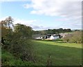
1
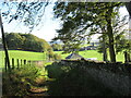
Track approaching Robiesland Cottage
The Robiesland farm buildings are visible in the distance.
Image: © Alan O'Dowd
Taken: 22 Oct 2021
0.04 miles
2
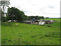
Bonninton Mains Farm
Livestock farm just to the south of Lanark.
Image: © G Laird
Taken: 6 Sep 2013
0.13 miles
3
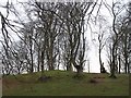
Clump of trees, Robbiesland
Parkland like farmland above the Falls of Clyde.
Image: © Richard Webb
Taken: 29 Mar 2008
0.13 miles
4
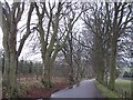
Beech lined road near Bonninton Mains
The road serves the Falls of Clyde power station as well as farms.
Image: © Richard Webb
Taken: 29 Mar 2008
0.13 miles
5
Bonnington Mains Farm
The term 'Mains' denotes the home farm of an estate, so presumably this farm was once associated with the Bonnington Estate, whose mansion house was destroyed by fire around a century ago.
Image: © Alan O'Dowd
Taken: 27 Oct 2017
0.14 miles
6
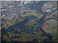
Lanark from the air
Looking over Bonnington Mains.
Image: © Thomas Nugent
Taken: 8 Dec 2017
0.20 miles