IMAGES TAKEN NEAR TO
West Nemphlar Road, LANARK, ML11 9GW
Introduction
This page details the photographs taken nearby to West Nemphlar Road, ML11 9GW by members of the Geograph project.
The Geograph project started in 2005 with the aim of publishing, organising and preserving representative images for every square kilometre of Great Britain, Ireland and the Isle of Man.

There are currently over 7.5m images from over14,400 individuals and you can help contribute to the project by visiting https://www.geograph.org.uk
Image Map
Images are licensed for reuse under creativecommons.org/licenses/by-sa/2.0
Notes
- Clicking on the map will re-center to the selected point.
- The higher the marker number, the further away the image location is from the centre of the postcode.
Image Listing (6 Images Found)
Images are licensed for reuse under creativecommons.org/licenses/by-sa/2.0
Image
Details
Distance
1

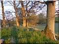
Sunset, Eastmore
House on the Lee Castle Estate near Lanark.
Image: © Alan O'Dowd
Taken: 10 May 2016
0.04 miles
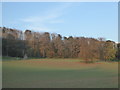
2
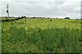
Trees on Chapel Knowe
A small knowe (knoll) in the Lee Castle policies - presumably a chapel was once sited nearby. The buildings just to the north-west are named as Chapel on a 19th Century map.
Image: © Alan O'Dowd
Taken: 10 May 2016
0.14 miles
3
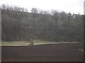
Tintochland
Remains of what appears to have been a farm. The A73 can be seen in the woods.
Image: © Richard Webb
Taken: 29 Mar 2008
0.17 miles
4
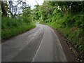
West Nemphlar Road
Steep bankings especially on right.
Image: © Jim Smillie
Taken: 23 Jun 2024
0.19 miles
6
Ruin at Tintochland
A gable-end is still standing on the site of a farm shown on 19th Century maps as Tintochland, the name possibly deriving from the Gaelic word 'teinnteach' (fiery), the likely derivation of the dominant local hill Tinto.
Image: © Alan O'Dowd
Taken: 10 May 2016
0.23 miles