IMAGES TAKEN NEAR TO
Bog Road, LANARK, ML11 8EX
Introduction
This page details the photographs taken nearby to Bog Road, ML11 8EX by members of the Geograph project.
The Geograph project started in 2005 with the aim of publishing, organising and preserving representative images for every square kilometre of Great Britain, Ireland and the Isle of Man.

There are currently over 7.5m images from over14,400 individuals and you can help contribute to the project by visiting https://www.geograph.org.uk
Image Map
Images are licensed for reuse under creativecommons.org/licenses/by-sa/2.0
Notes
- Clicking on the map will re-center to the selected point.
- The higher the marker number, the further away the image location is from the centre of the postcode.
Image Listing (8 Images Found)
Images are licensed for reuse under creativecommons.org/licenses/by-sa/2.0
Image
Details
Distance
1
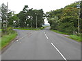
Road Junction north-west of Braehead
Both forks at this junction lead towards Forth.
Image: © G Laird
Taken: 12 Sep 2013
0.02 miles
3
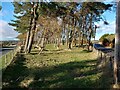
Copse at Y junction
The roads lead to either end of village of Forth
Image: © Jim Smillie
Taken: 4 Nov 2022
0.03 miles
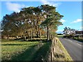
4
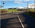
Minor road meets B7016 (Carnwath Road)
Heading to Braehead
Image: © Jim Smillie
Taken: 4 Nov 2022
0.03 miles
5

Sheep reflections
Sheep drinking by Maryville.
Image: © Callum Black
Taken: 29 Apr 2006
0.08 miles
6
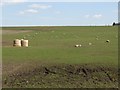
Back Brae
A scattering of bales, ewes, lambs and crows on the hill side to the north of Braehead.
Image: © Callum Black
Taken: 29 Apr 2006
0.10 miles
7
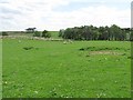
Grassland on the edge of Braehead Moss
One field with sheep and then the mosslands begin. Older maps suggest that this field was also covered in peat bog during the 20th century. The woodland area is around some quarry workings.
Image: © Richard Webb
Taken: 4 Jun 2010
0.14 miles
8
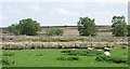
Braehead Moss
Raised bog, now a national nature reserve. View across one of the fields that was once reclaimed from the peat land.
Image: © Richard Webb
Taken: 4 Jun 2010
0.17 miles