1
Houses across the valley of the Mouse Water
On the edge of the historic Wilsontown Ironworks site.
Image: © M J Richardson
Taken: 17 Sep 2017
0.05 miles
2
Information board about the Wilsontown Inn
Now a ruin, it once served a population of around 2000 ironworkers.
Image: © M J Richardson
Taken: 17 Sep 2017
0.06 miles
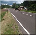
3
A706 at Wilsontown
A tributary of Mouse Water passes under the road here
Image: © Jim Smillie
Taken: 4 Aug 2021
0.07 miles
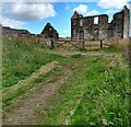
4
Ruin: Wilsontown Inn
Patrons from Pleasance Row would have approached from this direction
Image: © Jim Smillie
Taken: 4 Aug 2021
0.08 miles
5
The Wilsontown Inn
The ruins of one of the essential facilities at the historic ironworks site. It is not part of the Forestry Commission's property on the site, and is on the Buildings at Risk Register http://www.buildingsatrisk.org.uk/details/895256, and there are suggestions that it is to be restored by the owners.
Image: © M J Richardson
Taken: 17 Sep 2017
0.09 miles
6
The Wilsontown Inn
The ruins of the building, built in 1808, that has been a store, shop, masonic lodge and inn http://www.buildingsatrisk.org.uk/details/895256.
Image: © M J Richardson
Taken: 17 Sep 2017
0.09 miles
7
The valley of The Mouse at Wilsontown
This valley was the centre of the historic ironworks, with the furnaces, rolling mills, engine house and offices on either side of the stream. Rows of houses were on either side.
Image: © M J Richardson
Taken: 17 Sep 2017
0.09 miles
8
Wilsontown Inn ruin from the east
With rushes, reeds and grasses, and Heathland Forest beyond.
Image: © M J Richardson
Taken: 17 Sep 2017
0.09 miles
9
Wilsontown Inn from the north
The gable, and an adjoining range of lower buildings. With rushes and hair-grass.
Image: © M J Richardson
Taken: 17 Sep 2017
0.09 miles
10
Wilsontown
A remaining building in the forest, this was largely built up rather than forest once - site of the ironworks which were at their prime in the early 19th century but declined to eventual closure in the 1940s.
Image: © Richard Webb
Taken: 11 May 2006
0.10 miles


