IMAGES TAKEN NEAR TO
Lesmahagow, LANARK, ML11 0JD
Introduction
This page details the photographs taken nearby to ML11 0JD by members of the Geograph project.
The Geograph project started in 2005 with the aim of publishing, organising and preserving representative images for every square kilometre of Great Britain, Ireland and the Isle of Man.

There are currently over 7.5m images from over14,400 individuals and you can help contribute to the project by visiting https://www.geograph.org.uk
Image Map
Images are licensed for reuse under creativecommons.org/licenses/by-sa/2.0
Notes
- Clicking on the map will re-center to the selected point.
- The higher the marker number, the further away the image location is from the centre of the postcode.
Image Listing (6 Images Found)
Images are licensed for reuse under creativecommons.org/licenses/by-sa/2.0
Image
Details
Distance
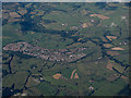
1
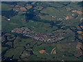
Kirkmuirhill from the air
Alongside the M74 motorway.
Image: © Thomas Nugent
Taken: 19 Jul 2015
0.02 miles
2
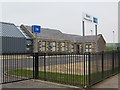
Bent Primary School
Out in the fields rather than in a village.
Image: © Richard Webb
Taken: 21 Apr 2014
0.06 miles
3
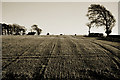
From Rogerhill to Bent
From the old railway line next to Rogerhill Farm, looking out towards a house by Bent School.
Image: © deemikay
Taken: 3 Feb 2007
0.10 miles
4
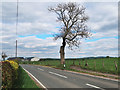
Strathaven Road near Bent
Bent Primary School buildings are on the left
Image: © wrobison
Taken: 13 May 2020
0.12 miles
5
Kirkmuirhill from the air
Alongside the M74 motorway.
Image: © Thomas Nugent
Taken: 19 Jul 2015
0.14 miles
6
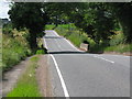
Road Bridge over the Cander water
At this point the Cander Water is not much more than a stream.
Image: © G Laird
Taken: 16 Aug 2013
0.22 miles