IMAGES TAKEN NEAR TO
Farthing Close, MILTON KEYNES, MK6 4NG
Introduction
This page details the photographs taken nearby to Farthing Close, MK6 4NG by members of the Geograph project.
The Geograph project started in 2005 with the aim of publishing, organising and preserving representative images for every square kilometre of Great Britain, Ireland and the Isle of Man.

There are currently over 7.5m images from over14,400 individuals and you can help contribute to the project by visiting https://www.geograph.org.uk
Image Map
Images are licensed for reuse under creativecommons.org/licenses/by-sa/2.0
Notes
- Clicking on the map will re-center to the selected point.
- The higher the marker number, the further away the image location is from the centre of the postcode.
Image Listing (17 Images Found)
Images are licensed for reuse under creativecommons.org/licenses/by-sa/2.0
Image
Details
Distance
1
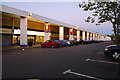
Local Shopping Centre, Netherfield, Milton Keynes.
The centre was finished aqround 1975.
Image: © Cameraman
Taken: 23 Jun 2009
0.07 miles


4
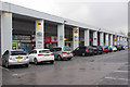
Netherfield Shopping Centre
There is quite a variety of shops in this local centre including a post office and Subway. The architecture is, however, perhaps a matter of taste.
Image: © Stephen McKay
Taken: 14 Nov 2019
0.08 miles
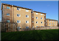
5
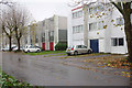
Farthing Grove, Netherfield
Terraced three storey houses opposite Netherfield shopping centre.
Image: © Stephen McKay
Taken: 14 Nov 2019
0.10 miles

7
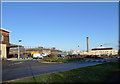
Hospital Services Area
The building lweft is the new Walk-in Centre.
Image: © Cameraman
Taken: 10 Dec 2009
0.11 miles
8

The Road Leading To The Main Entrance
Milton Keynes Hospital.
Image: © Cameraman
Taken: 10 Dec 2009
0.14 miles
10
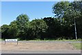
Standing Way, Milton Keynes
H8 stands for horizontal, with the verticals V. Milton Keynes is supposed to be built on a grid system but anyone from abroad who is familiar with actual grid systems will see this is being stretched when applied to here.
Image: © David Howard
Taken: 29 Jun 2019
0.18 miles