IMAGES TAKEN NEAR TO
Roebuck Way, MILTON KEYNES, MK5 8HL
Introduction
This page details the photographs taken nearby to Roebuck Way, MK5 8HL by members of the Geograph project.
The Geograph project started in 2005 with the aim of publishing, organising and preserving representative images for every square kilometre of Great Britain, Ireland and the Isle of Man.

There are currently over 7.5m images from over14,400 individuals and you can help contribute to the project by visiting https://www.geograph.org.uk
Image Map
Images are licensed for reuse under creativecommons.org/licenses/by-sa/2.0
Notes
- Clicking on the map will re-center to the selected point.
- The higher the marker number, the further away the image location is from the centre of the postcode.
Image Listing (10 Images Found)
Images are licensed for reuse under creativecommons.org/licenses/by-sa/2.0
Image
Details
Distance
1
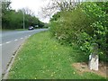
Milestone
Old milestone on what was the A.5 near to Shenley Church End, Milton Keynes. For close up view see http://www.geograph.org.uk/photo/5381027
Image: © Keith Evans
Taken: 22 Apr 2017
0.08 miles
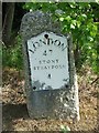
2
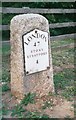
Old Milestone by the former A5 in Loughton, Milton Keynes
Metal plate attached to stone post by the UC road (was A5), in parish of Loughton (Milton Keynes District), Watling Street; Shenley Lodge, at junction with Kelvin Drive, North of Chaffron Way roundabout, on cut grass verge between road and fence, on North side of road. Milton Keynes alloy plate (New), erected by the Holyhead Road (Hockliffe Division) turnpike trust in the 20th century.
Inscription reads:-
LONDON
47
STONY STRATFORD
4
Milestone Society National ID: BU_LH47
Image: © A Rosevear & J Higgins
Taken: 11 Jul 2003
0.09 miles
3
Old Milestone
Old milestone on what was the A.5 near to Shenley Church End, Milton Keynes. For overall view see http://www.geograph.org.uk/photo/5381042
Image: © Keith Evans
Taken: 22 Apr 2017
0.09 miles
4
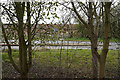
Trees by Kelvin Drive
Scrubby trees by the junction of Watling Street and Kelvin Drive.
Image: © Malcolm Neal
Taken: 27 Mar 2022
0.09 miles
5
Looking across Watling Street
On a dull misty day we had a short walk along the side of Watling Street.
Image: © Malcolm Neal
Taken: 27 Mar 2022
0.13 miles
7
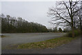
Is this an old car park?
Our walk has taken us close to the National Bowl and what might have been one of the car parks.
Image: © Malcolm Neal
Taken: 27 Mar 2022
0.17 miles
8
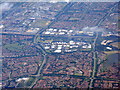
Knowlhill, Milton Keynes
Industrial and housing estates. The main road across the image is the A5 [Watling Street]; below it, at the RH edge, is part of The National Bowl and Furzton Lake.
Image: © M J Richardson
Taken: 26 Jun 2015
0.18 miles
9
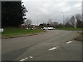
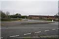
Milton Keynes : Knowlhill Roundabout
Approaching the roundabout from Childs Way.
Image: © Lewis Clarke
Taken: 19 Mar 2019
0.25 miles
10

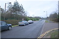
Looking across Childs Way
Childs Way is a typical Milton Keynes road which has many road junctions that all have a roundabout at the junction.
Image: © Malcolm Neal
Taken: 1 Nov 2020
0.25 miles