IMAGES TAKEN NEAR TO
Whitworth Lane, MILTON KEYNES, MK5 8EB
Introduction
This page details the photographs taken nearby to Whitworth Lane, MK5 8EB by members of the Geograph project.
The Geograph project started in 2005 with the aim of publishing, organising and preserving representative images for every square kilometre of Great Britain, Ireland and the Isle of Man.

There are currently over 7.5m images from over14,400 individuals and you can help contribute to the project by visiting https://www.geograph.org.uk
Image Map
Images are licensed for reuse under creativecommons.org/licenses/by-sa/2.0
Notes
- Clicking on the map will re-center to the selected point.
- The higher the marker number, the further away the image location is from the centre of the postcode.
Image Listing (28 Images Found)
Images are licensed for reuse under creativecommons.org/licenses/by-sa/2.0
Image
Details
Distance
1
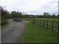
Swan's Way
Swan's Way heading along Whitworth Lane
Image: © Shaun Ferguson
Taken: 2 May 2014
0.09 miles
2
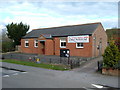
Loughton Memorial Hall, Loughton, Milton Keynes
A small village hall which made up part of the original village.
Image: © Mr Biz
Taken: 31 Mar 2008
0.11 miles
3
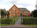
Loughton Baptist Church
The smaller of the two churches in the Loughton area.
Image: © Mr Biz
Taken: 31 Mar 2008
0.11 miles
4
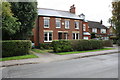
Nos. 34 and 32 Bradwell Road
There is an OS benchmark Image on the near corner, left hand face, of the semi-detached houses, right of the car parked in the drive.
Image: © Roger Templeman
Taken: 20 Oct 2016
0.11 miles
5
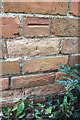
Benchmark on #34 Bradwell Road
Ordnance Survey cut mark benchmark described on the Bench Mark Database at http://www.bench-marks.org.uk/bm79886
Image: © Roger Templeman
Taken: 20 Oct 2016
0.11 miles
6
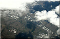
Milton Keynes from the air
Looking north over Knowhill to the city centre from a Birmingham bound flight from Prague.
Image: © Thomas Nugent
Taken: 11 Feb 2022
0.15 miles
7
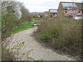
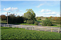
Meadow 2
Looking from the entrance near to Ashpole Furlong.
Image: © Malcolm Campbell
Taken: 30 Mar 2009
0.15 miles
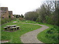
8
Loughton Millennium Meadow
Tucked away behind Bradwell Road and Gurney Close.
Image: © Malcolm Campbell
Taken: 30 Mar 2009
0.15 miles
9
Looking across Ashpole Furlong
Standing in the small children's playground looking across the appropriately named road near the equestrian centre.
Image: © Malcolm Neal
Taken: 30 Oct 2021
0.18 miles
10
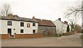
Buildings on Leys Road, Loughton
On the left is the former Wheatsheaf pub; on the right is the listed Salisbury House http://www.britishlistedbuildings.co.uk/en-45842-salisbury-house-3-loughton . Taken from the junction with School Lane.
Image: © Derek Harper
Taken: 4 Feb 2011
0.18 miles