IMAGES TAKEN NEAR TO
Higgs Court, MILTON KEYNES, MK5 8DP
Introduction
This page details the photographs taken nearby to Higgs Court, MK5 8DP by members of the Geograph project.
The Geograph project started in 2005 with the aim of publishing, organising and preserving representative images for every square kilometre of Great Britain, Ireland and the Isle of Man.

There are currently over 7.5m images from over14,400 individuals and you can help contribute to the project by visiting https://www.geograph.org.uk
Image Map
Images are licensed for reuse under creativecommons.org/licenses/by-sa/2.0
Notes
- Clicking on the map will re-center to the selected point.
- The higher the marker number, the further away the image location is from the centre of the postcode.
Image Listing (12 Images Found)
Images are licensed for reuse under creativecommons.org/licenses/by-sa/2.0
Image
Details
Distance
1
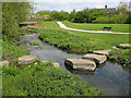
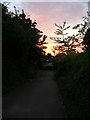
Stepping stones
Large stone blocks provide a means of crossing Loughton Brook. The footpath /cyclepath in the background is one of a network in Loughton Valley Park and, in the direction I am facing, will take you to Lodge Lake and Bradwell Abbey to the North.
Image: © Martin Addison
Taken: 3 May 2006
0.08 miles
2
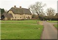
The Green, Loughton
Manor Farm Cottages (originally C16 and now one house http://www.britishlistedbuildings.co.uk/en-45851-manor-farm-cottages-7-and-8-loughton ) overlook the north side of this green.
Image: © Derek Harper
Taken: 4 Feb 2011
0.09 miles
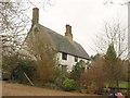
3
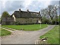
Thatched housing - Loughton
Amongst the modern housing of Milton Keynes, the Loughton valley retains many older buildings. This traditionally thatched house may once have been a farmhouse. The modern street light gives a clue to its city location.
Image: © Martin Addison
Taken: 3 May 2006
0.10 miles
4
Attingham Hill running down to Portway
Image: © Steve Daniels
Taken: 6 Apr 2017
0.13 miles
5
Path under Portway
Leading away from the lake.
Image: © DS Pugh
Taken: 8 Aug 2007
0.14 miles
6
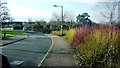
Linceslade Grove
Taken from end of section where cars are not permitted to park on verges. Dogwood on right is vegetation near the stream and drain
Image: © Clint Mann
Taken: 30 Jan 2015
0.14 miles
7
Farmhouse, Loughton
Cell Farmhouse has a steep-pitched roof - might that indicate it was once thatched? According to http://www.britishlistedbuildings.co.uk/en-45850-cell-farmhouse-1-loughton , it could be C16.
Image: © Derek Harper
Taken: 4 Feb 2011
0.16 miles
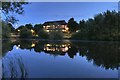
9
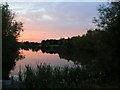
Lodge Lake
Looking across Lodge Lake from the southern end near Portway.
Image: © DS Pugh
Taken: 8 Aug 2007
0.18 miles
10
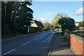
Bradwell Road
Looking along Bradwell Road on a bright sunny afternoon, much improved from the heavy rain of this morning when we were further north.
Image: © Malcolm Neal
Taken: 30 Oct 2021
0.18 miles