IMAGES TAKEN NEAR TO
Pigott Drive, MILTON KEYNES, MK5 6JN
Introduction
This page details the photographs taken nearby to Pigott Drive, MK5 6JN by members of the Geograph project.
The Geograph project started in 2005 with the aim of publishing, organising and preserving representative images for every square kilometre of Great Britain, Ireland and the Isle of Man.

There are currently over 7.5m images from over14,400 individuals and you can help contribute to the project by visiting https://www.geograph.org.uk
Image Map
Images are licensed for reuse under creativecommons.org/licenses/by-sa/2.0
Notes
- Clicking on the map will re-center to the selected point.
- The higher the marker number, the further away the image location is from the centre of the postcode.
Image Listing (37 Images Found)
Images are licensed for reuse under creativecommons.org/licenses/by-sa/2.0
Image
Details
Distance
1

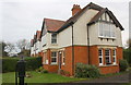
#3 Hedingham Court
The Ordnance Survey levelled a stud bolt benchmark on the near corner, right hand face, of the house in 1993. It is probably still there but hidden behind a wooden fence post, see http://www.bench-marks.org.uk/bm56702 for description on the Bench Mark Database
Image: © Roger Templeman
Taken: 23 Nov 2016
0.05 miles
2
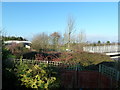
Selby Grove Cottages
There is an OS benchmark Image under the bay window on the side of the nearest house, which was formerly #1 Glastonbury Cottages.
Image: © Roger Templeman
Taken: 23 Nov 2016
0.10 miles
3
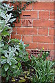
Benchmark on #52 Selby Grove
Ordnance Survey cut mark benchmark described on the Bench Mark Database at http://www.bench-marks.org.uk/bm80579
Image: © Roger Templeman
Taken: 23 Nov 2016
0.10 miles
4
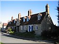
Six chimneys
Erected in 1615 and endowed for aged people by the good work of Sir Thomas Stafford.
Image: © Malcolm Campbell
Taken: 6 Mar 2009
0.15 miles
5
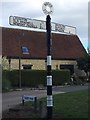
Old Direction Sign - Signpost by Shenley Road, Parish of Loughton
Annulus finial - 3 arms, 1 missing; Bucks County halo by the UC road, in parish of Loughton (Milton Keynes District), Shenley Church End, junction of Shenley Road with Oakhill Road, on verge at roundabout.
Surveyed
Milestone Society National ID: BU_SP8336
Image: © Milestone Society
Taken: Unknown
0.15 miles
6
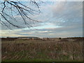
Three footbridges
Three footbridges visible from this point during the winter when the trees are bare.
Image: © Malcolm Campbell
Taken: 22 Dec 2011
0.15 miles
7
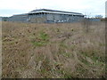
Santander warehouse
Data warehouse or where they store all of the paperwork. Clearly shows the natural grassland which has been left around the site.
Image: © Malcolm Campbell
Taken: 9 Jan 2012
0.16 miles
8
Santander premises
Santander offices at Shenley Wood - the building to the left is the Call Centre/Offices and the other is presumably the data centre.
Image: © Malcolm Campbell
Taken: 24 Dec 2011
0.16 miles
9
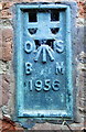
Benchmark on Manor Farm House
Ordnance Survey flush bracket (serial number 1956) benchmark described on the Bench Mark Database at http://www.bench-marks.org.uk/bm160
Image: © Roger Templeman
Taken: 23 Nov 2016
0.17 miles
10
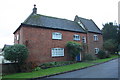
Manor Farm House, Shenley Road
There is an OS benchmark Image on the front of the house, left hand corner, behind a shrub
Image: © Roger Templeman
Taken: 23 Nov 2016
0.17 miles