IMAGES TAKEN NEAR TO
Clifton Reynes, OLNEY, MK46 5DT
Introduction
This page details the photographs taken nearby to MK46 5DT by members of the Geograph project.
The Geograph project started in 2005 with the aim of publishing, organising and preserving representative images for every square kilometre of Great Britain, Ireland and the Isle of Man.

There are currently over 7.5m images from over14,400 individuals and you can help contribute to the project by visiting https://www.geograph.org.uk
Image Map
Images are licensed for reuse under creativecommons.org/licenses/by-sa/2.0
Notes
- Clicking on the map will re-center to the selected point.
- The higher the marker number, the further away the image location is from the centre of the postcode.
Image Listing (15 Images Found)
Images are licensed for reuse under creativecommons.org/licenses/by-sa/2.0
Image
Details
Distance
1
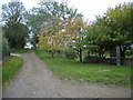
Public Footpath at Clifton Reynes
This public footpath leads from the centre of Clifton Reynes village across the meadows and a footbridge over the River Great Ouse to the market town of Olney. Notice the rural telephone box sheltering under the tree on the right.
Image: © Nigel Stickells
Taken: 14 Nov 2006
0.07 miles
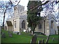
2
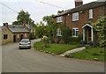
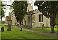
Clifton Reynes
Taken from the gateway to the church.
Image: © Cameraman
Taken: 20 May 2010
0.10 miles
3

Lane towards Clifton Reynes
The view down hill towards the village of Clifton Reynes. The recently established Ouse Valley Way passes along this lane. A useful http://www.ousevalleyway.org.uk/ to this 150 mile long distance footpath.
Image: © Michael Trolove
Taken: 11 Oct 2009
0.10 miles
4
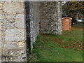
Bench Mark. Clifton Reynes Church
The familiar crows foot Bench Mark and not so familiar loo in Clifton Reynes churchyard. Additional information can be found at http://www.bench-marks.org.uk/bm33304 .
Image: © Michael Trolove
Taken: 11 Oct 2009
0.11 miles
5
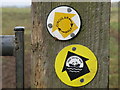
Footpath marker discs
The discs point the way for the Ouse Valley Way http://www.ousevalleyway.org.uk/ across the fields at Clifton Reynes.
Image: © Michael Trolove
Taken: 11 Oct 2009
0.11 miles
7
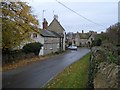
Clifton Reynes Village
Clifton Reynes is approached from along this no-through road. It is a small and unspoilt village mostly built of local stone. The Robin Hood is the village pub shown on the left. The Three Shire bridleway also passes through the village.
Image: © Nigel Stickells
Taken: 14 Nov 2006
0.12 miles
10
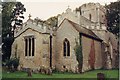
St Mary the Virgin at Clifton Reynes
The tower is Norman and much of the rest is 14th century, including tombs of that period with carved wooden effigies of knights of the Reynes family and their wives. There is a carved medieval dog unusually named 'BO' on its collar, upon which rest the feet of Sir Thomas Reynes III (d 1390). The church has a tranquil setting and the interior is well worth a visit.
Image: © Nigel Stickells
Taken: 26 Nov 2006
0.14 miles