IMAGES TAKEN NEAR TO
Snelson, OLNEY, MK46 4JB
Introduction
This page details the photographs taken nearby to Snelson, MK46 4JB by members of the Geograph project.
The Geograph project started in 2005 with the aim of publishing, organising and preserving representative images for every square kilometre of Great Britain, Ireland and the Isle of Man.

There are currently over 7.5m images from over14,400 individuals and you can help contribute to the project by visiting https://www.geograph.org.uk
Image Map
Images are licensed for reuse under creativecommons.org/licenses/by-sa/2.0
Notes
- Clicking on the map will re-center to the selected point.
- The higher the marker number, the further away the image location is from the centre of the postcode.
Image Listing (8 Images Found)
Images are licensed for reuse under creativecommons.org/licenses/by-sa/2.0
Image
Details
Distance
1
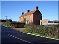
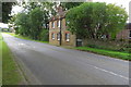
Snelson Cottages, Harrold Road, Lavendon
Snelson Cottages are on the Harrold Road leading from Lavendon and are closeby to the county border with Bedfordshire. They were originally a pair of farm cottages built for workers at the nearby house and farm of Snelson Manor that sits snugly beside the River Great Ouse.
Image: © Nigel Stickells
Taken: 21 Nov 2006
0.00 miles
2
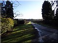
Driveway to Snelson Manor
This shows the view from the Lavendon-Harrold road down the driveway to Snelson Manor and Farm that sit beside the River Great Ouse and the Bedfordshire/Buckinghamshire county boundary.
Image: © Nigel Stickells
Taken: 21 Nov 2006
0.10 miles
3
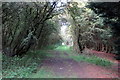
Milton Keynes Boundary Walk through the woods
Image: © Philip Jeffrey
Taken: 23 Sep 2017
0.12 miles
6

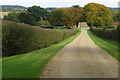
Tollgate Cottages near Lavendon
This was once a turnpike road (Kimbolton-Lavendon) which came under a turnpike trust in 1802. A tollgate was located at this point on the county border between Buckinghamshire and Bedfordshire. Tollgate Cottages on the left are in Bucks and Southfields Farm Cottage, hidden in the trees on the right is in Beds.
Image: © Nigel Stickells
Taken: 21 Nov 2006
0.17 miles
7
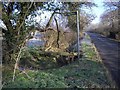
Footpath & Bridge from Harrold-Lavendon Road
The signpost points the way northwestwards over the footbridge where the Milton Keynes Boundary Walk leaves the Harrold-Lavendon Road 100yds north of the Beds/Bucks county border.
Image: © Nigel Stickells
Taken: 7 Feb 2007
0.24 miles
8
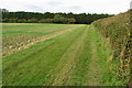
Milton Keynes Boundary Walk by Snelson
Image: © Philip Jeffrey
Taken: 23 Sep 2017
0.24 miles