IMAGES TAKEN NEAR TO
Mobbs Close, OLNEY, MK46 4DZ
Introduction
This page details the photographs taken nearby to Mobbs Close, MK46 4DZ by members of the Geograph project.
The Geograph project started in 2005 with the aim of publishing, organising and preserving representative images for every square kilometre of Great Britain, Ireland and the Isle of Man.

There are currently over 7.5m images from over14,400 individuals and you can help contribute to the project by visiting https://www.geograph.org.uk
Image Map (Loading...)


Getting Data...Please wait
Leaflet Map data © OpenStreetMap
Images are licensed for reuse under creativecommons.org/licenses/by-sa/2.0
Notes
- Clicking on the map will re-center to the selected point.
- The higher the marker number, the further away the image location is from the centre of the postcode.
Image Listing (55 Images Found)
Images are licensed for reuse under creativecommons.org/licenses/by-sa/2.0
Image
Details
Distance
1
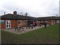
Olney Rugby Club House
Its February and the BBQ is up and running knocking out bacon butties for hungry players and spectators.
Image: © Michael Trolove
Taken: 22 Feb 2009
0.05 miles
3
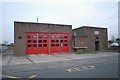
Olney fire station
Olney fire station, East Street, Olney, Buckinghamshire
Image: © Kevin Hale
Taken: 24 Nov 2007
0.06 miles
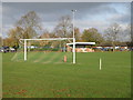
4
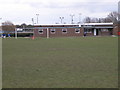
Olney Town Football Club
A multi sports location with football, rugby, tennis and children's play area all available.
Image: © Michael Trolove
Taken: 22 Feb 2009
0.07 miles
5
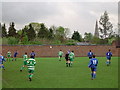
East Street - Olney Town Football Club
Olney are in green and playing league leaders Potton Town. All equipment including goals, flags and ropes have to be set up and taken down on matchdays. Note the parish church in the background.
Image: © nick macneill
Taken: 4 May 2004
0.08 miles
6
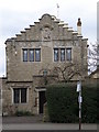
The Old Lace Factory
The former home of the Buckinghamshire Lace Industry. This link to the Olney museum gives details of lace making in and around Olney.http://www.mkheritage.co.uk/odhs/mainframe.html
Image: © Michael Trolove
Taken: 22 Feb 2009
0.09 miles
7
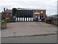
Brock's Garage
This is the rear or service entrance from East Street. The building runs through to face the High Street
Image: © Michael Trolove
Taken: 22 Feb 2009
0.09 miles
8
Pedestrian crossing along Olney High Street
Several houses along Olney high street have been converted from shops and buisneses , so we have The Old Bakery or the Old Forge. How long before we see the Old Nokia or the Old Spar as house names along any town high street.
Image: © Michael Trolove
Taken: 22 Feb 2009
0.10 miles
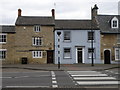
10
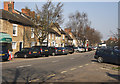
The High street, Olney
Cars can park down both sides of this wide high street but it is still difficult to find a parking place.
Image: © Cameraman
Taken: 8 Mar 2011
0.11 miles