IMAGES TAKEN NEAR TO
Park Meadow Close, BEDFORD, MK45 4SB
Introduction
This page details the photographs taken nearby to Park Meadow Close, MK45 4SB by members of the Geograph project.
The Geograph project started in 2005 with the aim of publishing, organising and preserving representative images for every square kilometre of Great Britain, Ireland and the Isle of Man.

There are currently over 7.5m images from over14,400 individuals and you can help contribute to the project by visiting https://www.geograph.org.uk
Image Map
Images are licensed for reuse under creativecommons.org/licenses/by-sa/2.0
Notes
- Clicking on the map will re-center to the selected point.
- The higher the marker number, the further away the image location is from the centre of the postcode.
Image Listing (42 Images Found)
Images are licensed for reuse under creativecommons.org/licenses/by-sa/2.0
Image
Details
Distance
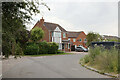
1

The Olde Watermill, Barton-le-Clay
It is now a shopping centre
Image: © David Howard
Taken: 3 Apr 2019
0.08 miles
3

The Olde Watermill, Barton-le-Clay
The site is now home for The Olde Watermill Shopping Village
Image: © PAUL FARMER
Taken: 8 Nov 2015
0.12 miles
4
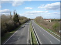
A6 heading north, Barton-le-Clay
From the bridge on Barton Road.
Image: © JThomas
Taken: 25 Mar 2016
0.13 miles

6
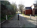
Dual use path off Mill Lane, Barton-le-Clay
Looking west.
Image: © JThomas
Taken: 25 Mar 2016
0.14 miles
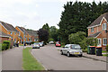
10
Sharpenhoe Road, Barton-le-Clay
Looking east.
Image: © JThomas
Taken: 25 Mar 2016
0.17 miles