IMAGES TAKEN NEAR TO
Brazier Close, BEDFORD, MK45 4RW
Introduction
This page details the photographs taken nearby to Brazier Close, MK45 4RW by members of the Geograph project.
The Geograph project started in 2005 with the aim of publishing, organising and preserving representative images for every square kilometre of Great Britain, Ireland and the Isle of Man.

There are currently over 7.5m images from over14,400 individuals and you can help contribute to the project by visiting https://www.geograph.org.uk
Image Map
Images are licensed for reuse under creativecommons.org/licenses/by-sa/2.0
Notes
- Clicking on the map will re-center to the selected point.
- The higher the marker number, the further away the image location is from the centre of the postcode.
Image Listing (34 Images Found)
Images are licensed for reuse under creativecommons.org/licenses/by-sa/2.0
Image
Details
Distance
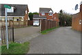
1
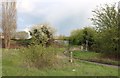
Path crossing the brook in Barton-Le-Clay
Image: © David Howard
Taken: 3 Apr 2019
0.06 miles
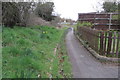
5
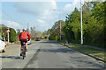
Cycling through Barton-le-Clay
On the B655 Bedford Road, towards Bedford.
Image: © Robin Webster
Taken: 2 May 2021
0.12 miles
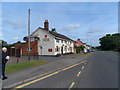
7

The Waggon & Horses,Barton Le Clay
Charles Wells Pub Company are now reletting this public house.
Image: © Raymond Cubberley
Taken: 11 Jul 2011
0.13 miles
9
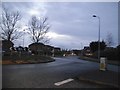
Roundabout on Bedford Road, Barton-le-Clay
Image: © David Howard
Taken: 28 Feb 2017
0.13 miles
10
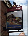
Sign for the Waggon & Horses, Barton-le-Clay
Image: © JThomas
Taken: 25 Mar 2016
0.14 miles