IMAGES TAKEN NEAR TO
Wilden Road, BEDFORD, MK44 2NJ
Introduction
This page details the photographs taken nearby to Wilden Road, MK44 2NJ by members of the Geograph project.
The Geograph project started in 2005 with the aim of publishing, organising and preserving representative images for every square kilometre of Great Britain, Ireland and the Isle of Man.

There are currently over 7.5m images from over14,400 individuals and you can help contribute to the project by visiting https://www.geograph.org.uk
Image Map
Images are licensed for reuse under creativecommons.org/licenses/by-sa/2.0
Notes
- Clicking on the map will re-center to the selected point.
- The higher the marker number, the further away the image location is from the centre of the postcode.
Image Listing (5 Images Found)
Images are licensed for reuse under creativecommons.org/licenses/by-sa/2.0
Image
Details
Distance
2
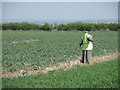
Headless in Roothams Green
It's a tough life out in the fields.
Image: © Michael Trolove
Taken: 24 Apr 2009
0.15 miles
3
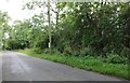
Footpath to Channel's End
Off Wilden Road footpath to Channel's End
Image: © Shaun Ferguson
Taken: 23 Feb 2010
0.17 miles
4
Cornfields restaurant, Rootham Green
Image: © Michael Trolove
Taken: 24 Apr 2009
0.17 miles
5
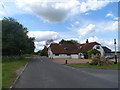
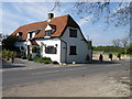
The former Wheatsheaf pub, Colmworth
It is now called the Cornfields and it is a restaurant/hotel. It was built in C17 with some C20 extensions. It is not known if the building was always a pub but it was certainly by 1822 (Register of Alehouse Recognizances-see http://www.bedfordshire.gov.uk/CommunityAndLiving/ArchivesAndRecordOffice/CommunityArchives/Colmworth/CornfieldsHotelColmworth.aspx). The Wheatsheaf closed in 1995.
Image: © Bikeboy
Taken: 30 May 2015
0.19 miles