IMAGES TAKEN NEAR TO
Station Road, BEDFORD, MK43 8BH
Introduction
This page details the photographs taken nearby to Station Road, MK43 8BH by members of the Geograph project.
The Geograph project started in 2005 with the aim of publishing, organising and preserving representative images for every square kilometre of Great Britain, Ireland and the Isle of Man.

There are currently over 7.5m images from over14,400 individuals and you can help contribute to the project by visiting https://www.geograph.org.uk
Image Map
Images are licensed for reuse under creativecommons.org/licenses/by-sa/2.0
Notes
- Clicking on the map will re-center to the selected point.
- The higher the marker number, the further away the image location is from the centre of the postcode.
Image Listing (12 Images Found)
Images are licensed for reuse under creativecommons.org/licenses/by-sa/2.0
Image
Details
Distance
1
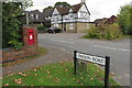
George VI postbox on the corner of station road
Image: © Philip Jeffrey
Taken: 30 Sep 2017
0.03 miles
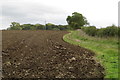
5
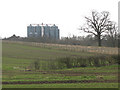
Disused grain silos near Elderswell Farm
A distant view like this gives a better impression of how these silos of a disused grain handling plant dominate the landscape than a close-up might.
As of August 2006 there was a planning application in for "Demolition of existing buildings and silos and the construction of 39 dwellings and 4 business units" but I could not find whether this has been granted.
Image: © Stephen Craven
Taken: 8 Mar 2009
0.14 miles
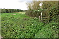
6
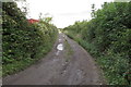
Track on the course of a dismantled railway
Image: © Philip Jeffrey
Taken: 30 Sep 2017
0.15 miles
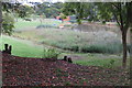
7
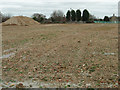
Former railway yard and grain store
Not much to see now but a couple of useful "links" showing the previous usage of this site. The first Image shows a distant view of the former Quenby Price/ Cargill grain silo and the second http://www.derelictplaces.co.uk/main/showthread.php?t=16390 is self explanatory.
Image: © Michael Trolove
Taken: 25 Jan 2012
0.16 miles