IMAGES TAKEN NEAR TO
Brook Lane, BEDFORD, MK43 8AP
Introduction
This page details the photographs taken nearby to Brook Lane, MK43 8AP by members of the Geograph project.
The Geograph project started in 2005 with the aim of publishing, organising and preserving representative images for every square kilometre of Great Britain, Ireland and the Isle of Man.

There are currently over 7.5m images from over14,400 individuals and you can help contribute to the project by visiting https://www.geograph.org.uk
Image Map (Loading...)


Getting Data...Please wait
Leaflet Map data © OpenStreetMap
Images are licensed for reuse under creativecommons.org/licenses/by-sa/2.0
Notes
- Clicking on the map will re-center to the selected point.
- The higher the marker number, the further away the image location is from the centre of the postcode.
Image Listing (11 Images Found)
Images are licensed for reuse under creativecommons.org/licenses/by-sa/2.0
Image
Details
Distance
1
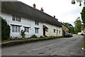
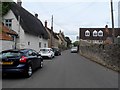
Cottages, Newton Blossomville
The thatched row is 18th century, grade II listed, now converted into just two houses.
Image: © Robin Webster
Taken: 4 Sep 2016
0.02 miles
2
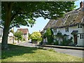
Thatched cottages, Newton Blossomville
Image: © Robin Drayton
Taken: 13 May 2008
0.04 miles
4
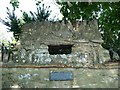
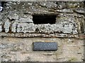
Defensive Position in Newton Blossomville
Visible above the Rectory wall, and facing up the road (behind camera), is a defensive gun slit with a plaque beneath which states "This loophole was constructed in 1940 for use by members of the home guard in case of invasion by Hitler's Armies - 8th May 1995"
Image: © Nigel Stickells
Taken: 14 Nov 2006
0.06 miles
7
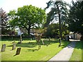
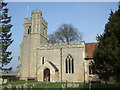
The parish church of St Nicholas, Newton Blossomville
The nave dates from the 11th century.
The chancel built at that time was re-built in the 13th century and enlarged to its present form in the 14th century.
The north chapel is 13th century.
The north aisle is 14th century.
The tower and porch are 15th century.
The church was extensively and sensitively restored in 1862.
Image: © sian harrison
Taken: 10 Feb 2008
0.10 miles
10
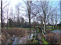
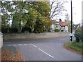
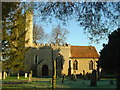
Ouse Valley walk after Newton Blossomville
The river Great Ouse is behind the photographer. St Nicholas' church can just be seen behind the trees. The picture was taken after rain - in the summer this is dry and adders nest here.
Image: © sian harrison
Taken: 1 Jan 2006
0.14 miles