IMAGES TAKEN NEAR TO
Turvey Road, BEDFORD, MK43 7LH
Introduction
This page details the photographs taken nearby to Turvey Road, MK43 7LH by members of the Geograph project.
The Geograph project started in 2005 with the aim of publishing, organising and preserving representative images for every square kilometre of Great Britain, Ireland and the Isle of Man.

There are currently over 7.5m images from over14,400 individuals and you can help contribute to the project by visiting https://www.geograph.org.uk
Image Map
Images are licensed for reuse under creativecommons.org/licenses/by-sa/2.0
Notes
- Clicking on the map will re-center to the selected point.
- The higher the marker number, the further away the image location is from the centre of the postcode.
Image Listing (2 Images Found)
Images are licensed for reuse under creativecommons.org/licenses/by-sa/2.0
Image
Details
Distance
2
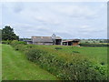
Pasture Land in the Great Ouse Valley
The hedgerow on the left is the parish boundary between Carlton and Turvey in Bedfordshire. The River Great Ouse is just visible in the shallow valley bottom. The county boundary with Buckinghamshire extends up to Tollgate Cottages far distance left, see SP9354.
Image: © Nigel Stickells
Taken: 4 Feb 2007
0.24 miles