IMAGES TAKEN NEAR TO
New Road, BEDFORD, MK43 7EP
Introduction
This page details the photographs taken nearby to New Road, MK43 7EP by members of the Geograph project.
The Geograph project started in 2005 with the aim of publishing, organising and preserving representative images for every square kilometre of Great Britain, Ireland and the Isle of Man.

There are currently over 7.5m images from over14,400 individuals and you can help contribute to the project by visiting https://www.geograph.org.uk
Image Map
Images are licensed for reuse under creativecommons.org/licenses/by-sa/2.0
Notes
- Clicking on the map will re-center to the selected point.
- The higher the marker number, the further away the image location is from the centre of the postcode.
Image Listing (3 Images Found)
Images are licensed for reuse under creativecommons.org/licenses/by-sa/2.0
Image
Details
Distance
1
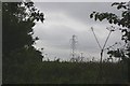
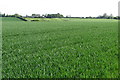
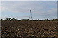
Pylon in field
There is no legitimate access to this square according to the map -- the one track never quite enters the square although it does get within a few metres of it in several places. Fortunately there was a break in the hedge with an unofficial track leading slightly into a field, from whence I was able to snatch this image through yet another hedge! The tops of the buildings at Manor Farm are just discernible above the foliage to the left of the pylon.
Image: © Fractal Angel
Taken: 19 Aug 2007
0.10 miles