IMAGES TAKEN NEAR TO
High Street, BEDFORD, MK43 7AX
Introduction
This page details the photographs taken nearby to High Street, MK43 7AX by members of the Geograph project.
The Geograph project started in 2005 with the aim of publishing, organising and preserving representative images for every square kilometre of Great Britain, Ireland and the Isle of Man.

There are currently over 7.5m images from over14,400 individuals and you can help contribute to the project by visiting https://www.geograph.org.uk
Image Map
Images are licensed for reuse under creativecommons.org/licenses/by-sa/2.0
Notes
- Clicking on the map will re-center to the selected point.
- The higher the marker number, the further away the image location is from the centre of the postcode.
Image Listing (38 Images Found)
Images are licensed for reuse under creativecommons.org/licenses/by-sa/2.0
Image
Details
Distance
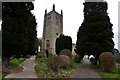
5
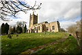
All Saints, Odell - SE elevation
Standing on its hillock, the church dominates the approach to Odell in both directions.
Image: © David Kemp
Taken: 17 Mar 2014
0.05 miles
8
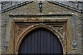
Odell, All Saints Church: South doorway detail
Image: © Michael Garlick
Taken: 22 Mar 2018
0.05 miles
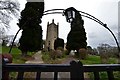
9
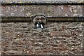
Odell: All Saints Church: Tower gargoyle
Image: © Michael Garlick
Taken: 22 Mar 2018
0.05 miles
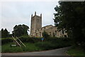
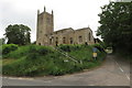
10
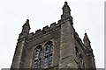
Odell, All Saints Church: c15th Perpendicular tower
Image: © Michael Garlick
Taken: 22 Mar 2018
0.05 miles