IMAGES TAKEN NEAR TO
Segenhoe, BEDFORD, MK43 0XW
Introduction
This page details the photographs taken nearby to Segenhoe, MK43 0XW by members of the Geograph project.
The Geograph project started in 2005 with the aim of publishing, organising and preserving representative images for every square kilometre of Great Britain, Ireland and the Isle of Man.

There are currently over 7.5m images from over14,400 individuals and you can help contribute to the project by visiting https://www.geograph.org.uk
Image Map
Images are licensed for reuse under creativecommons.org/licenses/by-sa/2.0
Notes
- Clicking on the map will re-center to the selected point.
- The higher the marker number, the further away the image location is from the centre of the postcode.
Image Listing (23 Images Found)
Images are licensed for reuse under creativecommons.org/licenses/by-sa/2.0
Image
Details
Distance
1
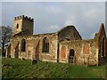
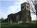
Segenhoe church
Remains of segenhoe church
Image: © Barry Ephgrave
Taken: 27 Dec 2009
0.01 miles
2
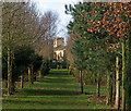
The way through the trees
Public footpath through a small wooded area on what is private land, probably belonging to Segenhoe Manor. The church in the distance is the ruined church of Segenhoe.
Way marker can be seen on the left of the image.
Image: © Dennis simpson
Taken: 2 Mar 2008
0.06 miles
3
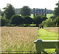
Close to Segenhoe Church
Large Georgian style house with formal gardens, a small footbridge and path cut through grass to a bench at the top of adjoining field. Viewed from John Bunyan Way footpath.
Image: © Dennis simpson
Taken: 28 Jun 2008
0.07 miles
4
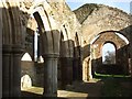
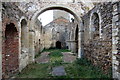
All Saints, Segenhoe - Nave, Arcade & Chancel
This interior shot of the ruined Image] looks along the nave to the chancel and the glassless East Window. On the left can be seen a fine arcade of mediæval columns which separated the nave from a narrow North Aisle, which may have formed a small side chapel at one time (see Image]).
Image: © Rob Farrow
Taken: 31 Jan 2007
0.08 miles
5
Inside the ruin of All Saints church
Image: © Philip Jeffrey
Taken: 19 Sep 2012
0.08 miles
6
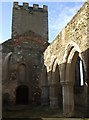
Inside All Saints, Segenhoe
This view of the interior of the ruined church of Image] is looking roughly westwards* in the direction of the tower. The arcading to the right separates the nave from a northern aisle which formed a side chapel. A view inside the tower can be seen here Image]
* Churches usually lie East/West with the tower or spire at the western end and the chancel and altar at the eastern end. However, as with its successor at Ridgmont, this church is oriented about 15º off true such that it lies roughly ENE/WSW. Interestingly this is pretty much the same error as seen at Ridgmont, making the two churches parallel.
Image: © Rob Farrow
Taken: 31 Jan 2007
0.08 miles
7
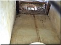
Inside the tower of All Saints, Segenhoe
This is a view up inside the tower of the ruined church of Image]
Image: © Rob Farrow
Taken: 31 Jan 2007
0.08 miles
8
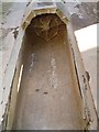
Niche, North Aisle, All Saints, Segenhoe
This little vertical niche is on the eastern wall of the northern side aisle of the ruined Image It would almost certainly have once held the statue of a saint, or quite possibly the Virgin & Child. The aisle could then have served as a side chapel. See the arcading separing this aisle from the nave here Image]
Image: © Rob Farrow
Taken: 31 Jan 2007
0.08 miles
9
Segenhoe Church from the gate
A view of Image] taken from near the Image] - from this angle it is not immediately obvious that the church is a shell.
Image: © Rob Farrow
Taken: 31 Jan 2007
0.08 miles
10
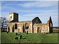
All Saints, Segenhoe
Now it has to be said that this church has seen better days ! This fascinating little ruin sits in a quiet spot near Segenhoe Manor. An Image] tells more about its fate.
EH Grade II* listing: https://historicengland.org.uk/listing/the-list/list-entry/1114056?section=official-list-entry
Scheduled Ancient Monument listing (rather scanty): https://historicengland.org.uk/listing/the-list/list-entry/1005402
Image: © Rob Farrow
Taken: 31 Jan 2007
0.08 miles