IMAGES TAKEN NEAR TO
Boughton End, BEDFORD, MK43 0QU
Introduction
This page details the photographs taken nearby to Boughton End, MK43 0QU by members of the Geograph project.
The Geograph project started in 2005 with the aim of publishing, organising and preserving representative images for every square kilometre of Great Britain, Ireland and the Isle of Man.

There are currently over 7.5m images from over14,400 individuals and you can help contribute to the project by visiting https://www.geograph.org.uk
Image Map
Images are licensed for reuse under creativecommons.org/licenses/by-sa/2.0
Notes
- Clicking on the map will re-center to the selected point.
- The higher the marker number, the further away the image location is from the centre of the postcode.
Image Listing (13 Images Found)
Images are licensed for reuse under creativecommons.org/licenses/by-sa/2.0
Image
Details
Distance
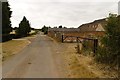
1
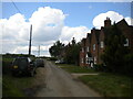
Boughton End Lane, Boughton End
This appears to be the entire hamlet of Boughton End; Boughton End Farm is a little way behind the photographer.
Image: © Richard Vince
Taken: 7 May 2022
0.01 miles
2
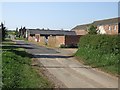
Boughton End
Farm building along the lane through the hamlet of Boughton End near Lidlington.
Image: © Rob Farrow
Taken: 2 May 2007
0.06 miles
3
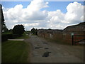
Boughton End Lane passing Boughton End Farm
Showing evidence of recent carriageway patching. This section of the road is part of the Greensand Ridge Walk, between two public footpaths that are about 100 yards apart.
Image: © Richard Vince
Taken: 7 May 2022
0.07 miles
4
Boughton End
Finger posts for the Greensand Ridge Walk can be seen to the right of the photograph.
Image: © Mark Anderson
Taken: 22 Jul 2018
0.08 miles
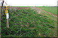
5
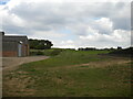
Spot the public footpath, Boughton End Farm
One of those sections of footpath that looks like it ought to be obvious from the 1:25,000 OS map but really isn't on the ground. Thankfully, I had approached from the copse visible atop the hill, so I was able to follow it as far as the point at which it petered out next to the farm building on the left and then simply aim for the way out onto the road. The path forms part of the Greensand Ridge Walk.
Image: © Richard Vince
Taken: 7 May 2022
0.09 miles
6
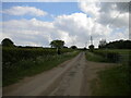
Boughton End Lane south east of Boughton End Farm
Looking towards the A507.
Image: © Richard Vince
Taken: 7 May 2022
0.09 miles
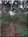
8
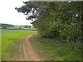
Public footpath north of Boughton End Farm (2)
Curving gently downhill towards the farm, forming part of the Greensand Ridge Walk.
Image: © Richard Vince
Taken: 7 May 2022
0.16 miles
9
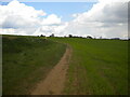
Public footpath north of Boughton End Farm (1)
Meandering in the general direction of Lidlington.
Image: © Richard Vince
Taken: 7 May 2022
0.18 miles