IMAGES TAKEN NEAR TO
Roxhill Road, BEDFORD, MK43 0QG
Introduction
This page details the photographs taken nearby to Roxhill Road, MK43 0QG by members of the Geograph project.
The Geograph project started in 2005 with the aim of publishing, organising and preserving representative images for every square kilometre of Great Britain, Ireland and the Isle of Man.

There are currently over 7.5m images from over14,400 individuals and you can help contribute to the project by visiting https://www.geograph.org.uk
Image Map
Images are licensed for reuse under creativecommons.org/licenses/by-sa/2.0
Notes
- Clicking on the map will re-center to the selected point.
- The higher the marker number, the further away the image location is from the centre of the postcode.
Image Listing (9 Images Found)
Images are licensed for reuse under creativecommons.org/licenses/by-sa/2.0
Image
Details
Distance
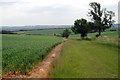
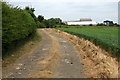
1
Entrance to Roxhill Manor Farm
The 20mph speed limit sign marks the end of the public road and the start of the farm road, which is a public bridleway.
Image: © David Hawgood
Taken: 20 Jun 2007
0.01 miles
2
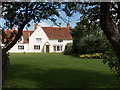
Roxhill Manor Farm
The farmhouse, view from road and bridleway through farm.
Image: © David Hawgood
Taken: 20 Jun 2007
0.03 miles
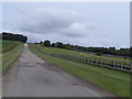
3
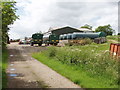
Roxhill Manor Farmyard
A large farm with a variety of agricultural machinery.
Image: © David Hawgood
Taken: 20 Jun 2007
0.09 miles
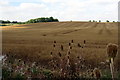
5
John Bunyan Trail on the track to Roxhill Manor Farm
Image: © Philip Jeffrey
Taken: 27 Jun 2013
0.16 miles
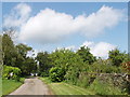
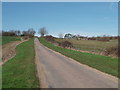
6
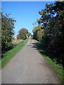
Lane from Roxhill Manor Farm to Ashbrook Farm
This is a public bridleway connecting Roxhill Manor Farm to Ashbrook Farm. It forms part of the John Bunyan Trail.
Image: © Robert Kerr
Taken: 28 Sep 2011
0.19 miles