IMAGES TAKEN NEAR TO
Beancroft Road, BEDFORD, MK43 0PY
Introduction
This page details the photographs taken nearby to Beancroft Road, MK43 0PY by members of the Geograph project.
The Geograph project started in 2005 with the aim of publishing, organising and preserving representative images for every square kilometre of Great Britain, Ireland and the Isle of Man.

There are currently over 7.5m images from over14,400 individuals and you can help contribute to the project by visiting https://www.geograph.org.uk
Image Map
Images are licensed for reuse under creativecommons.org/licenses/by-sa/2.0
Notes
- Clicking on the map will re-center to the selected point.
- The higher the marker number, the further away the image location is from the centre of the postcode.
Image Listing (20 Images Found)
Images are licensed for reuse under creativecommons.org/licenses/by-sa/2.0
Image
Details
Distance
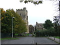
1
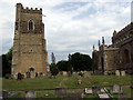
Marston Moretaine Church
The church is odd in that the churchtower is actually a short distance from the main church building!
Image: © Alan Simkins
Taken: 22 Jun 2003
0.02 miles
2
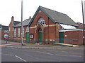
Bedford Road Methodist Chapel, Marston Moretaine
Image: © Mr Biz
Taken: 20 Nov 2010
0.06 miles
3
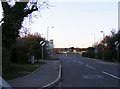
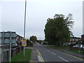
Island View
The view along Beancroft Road in Marston Moretaine.
Image: © Gordon Griffiths
Taken: 11 Nov 2018
0.08 miles
4
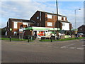
The co-operative at Marston Moretaine
General store at the junction of Bedford and Station Roads. Turn right here for the main entrance to the Forest Centre and Millennium Country Park Visitor Centre.
Image: © M J Richardson
Taken: 28 Nov 2011
0.10 miles
5
Marston Mortaine
This 1960s shopping precinct is beginning to show signs of decay.
Image: © Burgess Von Thunen
Taken: 18 Feb 2013
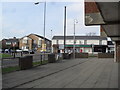
0.10 miles
7
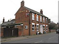
The Bell at Marston Moretaine
On Woburn Road, which is a continuation of Bedford Road, and would have been the main road through the village until it was by-passed.
Image: © M J Richardson
Taken: 28 Nov 2011
0.11 miles
8
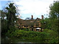
Moreteyne Manor
Looking across the moat to Moreteyne Manor, now a restaurant, formerly known as Moat Farm in Marston Moretaine
Image: © Paul Billington
Taken: 22 Aug 2004
0.18 miles
9
St. Mary's Church, Marston Moretaine
The church of St. Mary's in Marston Moretaine in Bedfordshire. The church dates from the 15th Century. Unusually, the tower is detached from the main building.
More information about the church can be found on its website: http://www.stmarysmarston.co.uk/
Image: © Malc McDonald
Taken: 20 Oct 2012
0.20 miles
10

Petrol Station, Marston Moretaine, Bedfordshire
Image: © Stacey Harris
Taken: 4 Nov 2009
0.21 miles