IMAGES TAKEN NEAR TO
Snagge Court, BEDFORD, MK43 0LF
Introduction
This page details the photographs taken nearby to Snagge Court, MK43 0LF by members of the Geograph project.
The Geograph project started in 2005 with the aim of publishing, organising and preserving representative images for every square kilometre of Great Britain, Ireland and the Isle of Man.

There are currently over 7.5m images from over14,400 individuals and you can help contribute to the project by visiting https://www.geograph.org.uk
Image Map
Images are licensed for reuse under creativecommons.org/licenses/by-sa/2.0
Notes
- Clicking on the map will re-center to the selected point.
- The higher the marker number, the further away the image location is from the centre of the postcode.
Image Listing (23 Images Found)
Images are licensed for reuse under creativecommons.org/licenses/by-sa/2.0
Image
Details
Distance
1
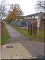
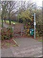
Public Footpath
Joining up with the footpath in SP9942 at the back of the sports ground, this footpath starts just past the bus shelter on Bedford Road.
Image: © Mr Biz
Taken: 20 Nov 2010
0.03 miles
2

Lounge of India, Caulcott
The Lounge of India, a pub and restaurant in the village of Caulcott, Bedfordshire.
Image: © Malc McDonald
Taken: 20 Oct 2012
0.03 miles
3
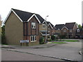
Horseshoe Close, Caulcott
Horseshoe Close is a new housing development in the village of Caulcott, Bedfordshire.
Image: © Malc McDonald
Taken: 20 Oct 2012
0.05 miles
4
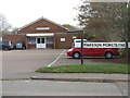
Marston Moreteyne Village Hall
A variant spelling of what seems to be the more usual Marston Moretaine.
Image: © M J Richardson
Taken: 28 Nov 2011
0.07 miles
5
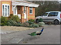
Free-range peacock at Caulcott
On Allen Court, a small cul-de-sac, with a path leading to Stewartby Lake
Image: © M J Richardson
Taken: 28 Nov 2011
0.08 miles
6
Public Footpath
This footpath runs from the Bedford Road Sports Ground in Marston Moretaine, over the A421 and towards Lower Shelton.
Image: © Mr Biz
Taken: 20 Nov 2010
0.10 miles
7
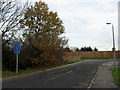
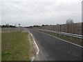
Lower Shelton Road
Lower Shelton Road used to link Lower Shelton with Caulcott but has recently been diverted due to the improvement of the A421.
Image: © Burgess Von Thunen
Taken: 24 Nov 2011
0.10 miles
8
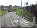
Subway under the A421, Lower Shelton
The A421 main road has cut the local road through the village of Lower Shelton. A subway enables pedestrians and cyclists to cross beneath the A421.
Image: © Malc McDonald
Taken: 20 Oct 2012
0.10 miles
9
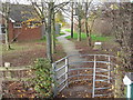
Footpath at Marston Moretaine
Heading along the side of the playing field.
Image: © M J Richardson
Taken: 28 Nov 2011
0.11 miles
10
Lower Shelton Road
Access road to Lower Shelton, part of the improvements to the A421.
Image: © Burgess Von Thunen
Taken: 6 Mar 2012
0.12 miles