IMAGES TAKEN NEAR TO
Bourne End, Cranfield, BEDFORD, MK43 0AX
Introduction
This page details the photographs taken nearby to MK43 0AX by members of the Geograph project.
The Geograph project started in 2005 with the aim of publishing, organising and preserving representative images for every square kilometre of Great Britain, Ireland and the Isle of Man.

There are currently over 7.5m images from over14,400 individuals and you can help contribute to the project by visiting https://www.geograph.org.uk
Image Map
Images are licensed for reuse under creativecommons.org/licenses/by-sa/2.0
Notes
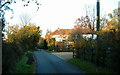
- Clicking on the map will re-center to the selected point.
- The higher the marker number, the further away the image location is from the centre of the postcode.
Image Listing (16 Images Found)
Images are licensed for reuse under creativecommons.org/licenses/by-sa/2.0
Image
Details
Distance
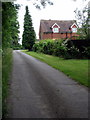
3
Bourne End marked the Diamond Jubilee
1952 EIIR 2012
Image: © M J Richardson
Taken: 18 Nov 2015
0.14 miles
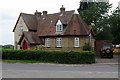
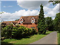
4
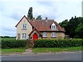
Old school house, Bourne End
Now a dwelling.
Image: © Bikeboy
Taken: 29 Jun 2013
0.16 miles
7
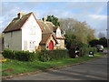
The Old School House, Bourne End
With a roadside honesty plant stall.
Image: © M J Richardson
Taken: 18 Nov 2015
0.16 miles
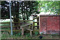
9
House in Bourne End
Next to the Manor House, by Hill Green Farm.
Image: © David Hawgood
Taken: 20 Jun 2007
0.17 miles
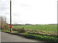
10
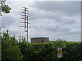
Aerial, Bourne End
Labelled on the O.S. map as "Radio Station-Aircraft", I'm not sure exactly what this is for.
Image: © Bikeboy
Taken: 29 Jun 2013
0.17 miles