IMAGES TAKEN NEAR TO
Everley Close, MILTON KEYNES, MK4 2ET
Introduction
This page details the photographs taken nearby to Everley Close, MK4 2ET by members of the Geograph project.
The Geograph project started in 2005 with the aim of publishing, organising and preserving representative images for every square kilometre of Great Britain, Ireland and the Isle of Man.

There are currently over 7.5m images from over14,400 individuals and you can help contribute to the project by visiting https://www.geograph.org.uk
Image Map
Images are licensed for reuse under creativecommons.org/licenses/by-sa/2.0
Notes
- Clicking on the map will re-center to the selected point.
- The higher the marker number, the further away the image location is from the centre of the postcode.
Image Listing (10 Images Found)
Images are licensed for reuse under creativecommons.org/licenses/by-sa/2.0
Image
Details
Distance
1
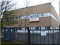
Telephone Exchange, Emerson Valley
Situated in Wolfscote Lane, this TE replaced the former TE in Shenley Church End sometime during the 1980s. Besides Emerson Valley, this TE also serves Furzton, Kingsmead, Nash, Shenley Brook End, Shenley Church End, Tattenhoe, Westcroft and Whaddon nearby. The BT warning notice has been fixed on the gate whilst to the left of the photo, a power generator can be seen. This TE is one of five such TEs that provide telephone and broadband services to Milton Keynes and has the numbering ranges (01908) 50xxxx, 52xxxx. The postcode of this TE is MK4 2BD.
Image: © David Hillas
Taken: 16 Mar 2013
0.08 miles
2
Emerson Valley Middle School
A view from the rear of the school off Hodder Lane, Emerson Valley.
Image: © Mr Biz
Taken: 27 Jul 2006
0.16 miles
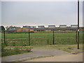
4
Fulmer Street
Heading towards the local rugby ground for a junior Park Run for our grand children.
Image: © Malcolm Neal
Taken: 16 Oct 2022
0.18 miles
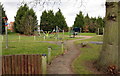
5
Wenning Lane
Looking from the rugby club car park across to Wenning Lane as we walk to the start of the junior Park Run.
Image: © Malcolm Neal
Taken: 16 Oct 2022
0.19 miles
6
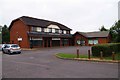
Medical facilities, Dulverton Drive, Furzton, Milton Keynes
From left to right:- Furzton Dental Centre, Furzton Medical Centre and Jardines Pharmacy.
Image: © P L Chadwick
Taken: 20 Jul 2014
0.20 miles
7
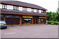
Shops in Dulverton Drive, Furzton, Milton Keynes
A local centre with various amenities including shops. The ones in this view are Essential Barbers, North Furzton Fish Bar and Hong Kong (Chinese food takeaway).
Image: © P L Chadwick
Taken: 20 Jul 2014
0.21 miles
8
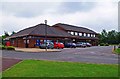
Tesco Express, 41 Dulverton Drive, Furzton, Milton Keynes
A Tesco convenience store in this local centre. To its right are a parade of shops which can also be seen here:- Image
Image: © P L Chadwick
Taken: 20 Jul 2014
0.22 miles
9

Furzton Bike share station
One of the new Milton Keynes cycle sharing points
Image: © Philip Jeffrey
Taken: 27 Jun 2016
0.24 miles
10
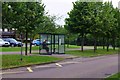
Bus shelter in Dulverton Drive, Furzton, Milton Keynes
It was a Sunday morning and probably the solitary prospective passenger was going to have quite a long wait. Behind are the local shops.
Image: © P L Chadwick
Taken: 20 Jul 2014
0.25 miles