IMAGES TAKEN NEAR TO
Bassie Close, BEDFORD, MK42 9JZ
Introduction
This page details the photographs taken nearby to Bassie Close, MK42 9JZ by members of the Geograph project.
The Geograph project started in 2005 with the aim of publishing, organising and preserving representative images for every square kilometre of Great Britain, Ireland and the Isle of Man.

There are currently over 7.5m images from over14,400 individuals and you can help contribute to the project by visiting https://www.geograph.org.uk
Image Map
Images are licensed for reuse under creativecommons.org/licenses/by-sa/2.0
Notes
- Clicking on the map will re-center to the selected point.
- The higher the marker number, the further away the image location is from the centre of the postcode.
Image Listing (41 Images Found)
Images are licensed for reuse under creativecommons.org/licenses/by-sa/2.0
Image
Details
Distance
1

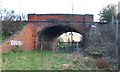
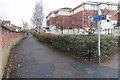
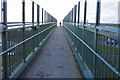
Old railway bridge on Elstow Road, Bedford
This crossed the Bedford - Hitchin line, closed in 1964. The trackbed is now built on to either side of the bridge.
Image: © Robin Webster
Taken: 9 Dec 2017
0.03 miles
2
Elstow Road bridge over old Hitchin to Bedford railway
Image: © d brewerton
Taken: Unknown
0.05 miles
3
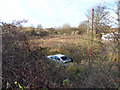
Waste land, Bedford
Looking from Elstow Road at what I at first thought was old railway land, but looking at old maps, it never really was, although the far side bordered the railway. On a 1901 map only, one siding, probably private, appears across the middle, but no buildings have ever been mapped. Was it some sort of temporary military depot?
Image: © Robin Webster
Taken: 9 Dec 2017
0.07 miles
4

Course of old railway, Bedford
Looking from the Elstow Road bridge at where the Bedford - Hitchin line once was. This closed in 1964.
Image: © Robin Webster
Taken: 9 Dec 2017
0.08 miles
5
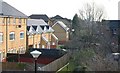
Houses on old trackbed looking south from Elstow Road bridge
Image: © d brewerton
Taken: Unknown
0.08 miles
6
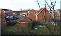
Houses on old trackbed looking north from Elstow Road bridge
Image: © d brewerton
Taken: Unknown
0.10 miles
8
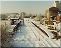
Bedford St. Johns railway station, 1981
Opened in 1846 by the London & North Western Railway on the Oxford to Cambridge line, this station closed in 1984 when the Bedford-Bletchley service was rerouted into the main Bedford station via a new St Johns station. View south west.
Image: © Nigel Thompson
Taken: 12 Dec 1981
0.14 miles
10
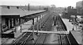
Bedford St Johns (former) Station
Cambridge - Bletchley line, which was closed on 1/1/68, view SW towards Bletchley (left), the connection to Bedford Midland Road being to the right. This station survived as a terminus until on 14/5/84 a replacement station was opened on the loop to Midland Road station and Bletchley trains then terminated there.
Image: © Ben Brooksbank
Taken: 4 Jun 1962
0.15 miles