IMAGES TAKEN NEAR TO
Crouch Gardens, BEDFORD, MK42 7GZ
Introduction
This page details the photographs taken nearby to Crouch Gardens, MK42 7GZ by members of the Geograph project.
The Geograph project started in 2005 with the aim of publishing, organising and preserving representative images for every square kilometre of Great Britain, Ireland and the Isle of Man.

There are currently over 7.5m images from over14,400 individuals and you can help contribute to the project by visiting https://www.geograph.org.uk
Image Map
Images are licensed for reuse under creativecommons.org/licenses/by-sa/2.0
Notes
- Clicking on the map will re-center to the selected point.
- The higher the marker number, the further away the image location is from the centre of the postcode.
Image Listing (20 Images Found)
Images are licensed for reuse under creativecommons.org/licenses/by-sa/2.0
Image
Details
Distance

6
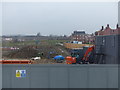
Construction work to the north of the Premier Inn at Kempston
Image: © Rob Purvis
Taken: 9 Mar 2018
0.14 miles
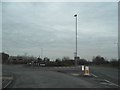
7
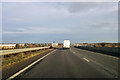
A421 at Marsh Leys Junction
A grade separated junction, with the main route passing over the top of the roundabout.
Image: © Robin Webster
Taken: 9 Dec 2017
0.15 miles
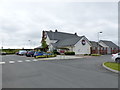
8
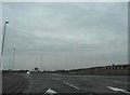
Roundabout on The Branston Way, Kempston
Image: © David Howard
Taken: 12 Mar 2017
0.16 miles
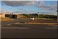
10
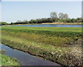
Top marks for the planners
This area is surrounded by ugly out of town retail units.At least someone has developed this lovely water area to soften the area.
Image: © Michael Wilson
Taken: 19 Apr 2007
0.18 miles