IMAGES TAKEN NEAR TO
Saunders Field, BEDFORD, MK42 7GG
Introduction
This page details the photographs taken nearby to Saunders Field, MK42 7GG by members of the Geograph project.
The Geograph project started in 2005 with the aim of publishing, organising and preserving representative images for every square kilometre of Great Britain, Ireland and the Isle of Man.

There are currently over 7.5m images from over14,400 individuals and you can help contribute to the project by visiting https://www.geograph.org.uk
Image Map
Images are licensed for reuse under creativecommons.org/licenses/by-sa/2.0
Notes
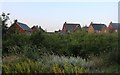
- Clicking on the map will re-center to the selected point.
- The higher the marker number, the further away the image location is from the centre of the postcode.
Image Listing (21 Images Found)
Images are licensed for reuse under creativecommons.org/licenses/by-sa/2.0
Image
Details
Distance
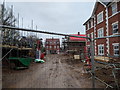
1
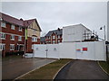
New houses and the road blocked for ongoing construction
Image: © Rob Purvis
Taken: 9 Mar 2018
0.04 miles
2
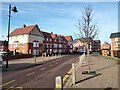
Martell Drive, Kempston
View looking down Martell Drive from Lidl Supermarket.
Image: © N Avery
Taken: 28 Jan 2022
0.04 miles
3
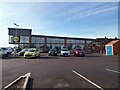
Lidl Supermarket, Kempston
View from Martell Drive.
Image: © N Avery
Taken: 28 Jan 2022
0.04 miles
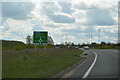
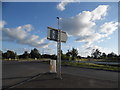
7
A6 The Branston Way at Ridge Road roundabout
Image: © Colin Pyle
Taken: 13 May 2022
0.10 miles
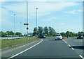
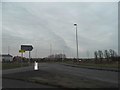
8
Roundabout on The Branston Way, Kempston
Image: © David Howard
Taken: 11 Jun 2017
0.12 miles
9
Ridge Road at the junction of The Branston Way
The houses have gone up in the last couple of years, encroaching into the green belt.
Image: © David Howard
Taken: 12 Mar 2017
0.13 miles