IMAGES TAKEN NEAR TO
Palstra, BEDFORD, MK42 0WS
Introduction
This page details the photographs taken nearby to Palstra, MK42 0WS by members of the Geograph project.
The Geograph project started in 2005 with the aim of publishing, organising and preserving representative images for every square kilometre of Great Britain, Ireland and the Isle of Man.

There are currently over 7.5m images from over14,400 individuals and you can help contribute to the project by visiting https://www.geograph.org.uk
Image Map (Loading...)


Getting Data...Please wait
Leaflet Map data © OpenStreetMap
Images are licensed for reuse under creativecommons.org/licenses/by-sa/2.0
Notes
- Clicking on the map will re-center to the selected point.
- The higher the marker number, the further away the image location is from the centre of the postcode.
Image Listing (21 Images Found)
Images are licensed for reuse under creativecommons.org/licenses/by-sa/2.0
Image
Details
Distance
1
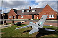
Model plane in front of the Air Cadets building
Image: © Philip Jeffrey
Taken: 3 Oct 2014
0.06 miles
2
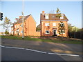
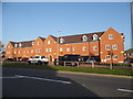
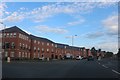
New houses on High Road, Shortstown
These are at the start of the new A600 bypass which goes round the village.
Image: © David Howard
Taken: 15 Oct 2017
0.06 miles
3
New road and housing in Shortstown
The A600 High Road has been diverted around the original one and has had a new housing estate built alongside it.
Image: © David Howard
Taken: 15 Oct 2017
0.09 miles
4
Beginning of new road construction towards the hangars
Image: © Philip Jeffrey
Taken: 3 Oct 2014
0.10 miles
5
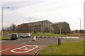
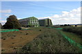
Roundabout on A600 at Shortstown
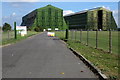
This roundabout gives access to the southern end of Shortstown and was funded for as part of recent expansion of the original village west of the A600. More significant expansion is planned for the old airfield site to the east, and the original intention was that this would be the start of a relief road round the village. However, latest plans approved by the Office of the Deputy Prime Minister, overriding local preferences, would see a widened A600 cutting through the middle of the expanded village.
In the background are the two Grade II* airship sheds, built in 1918 and 1926 and a dominant feature of the landscape south of Bedford.
Image: © Ian Capper
Taken: 13 Mar 2008
0.11 miles
6
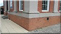
Pseudo Benchmark
Recently cut benchmark on Shorts Building. Former RAF Cardington.
Image: © Geoboy
Taken: 14 Jun 2016
0.13 miles
7
New housing on Carmichael Drive, Shortstown
Image: © David Howard
Taken: 29 Jul 2019
0.16 miles
8
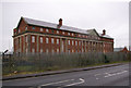
The Shorts Building, Cardington airfield
Built in 1917 (on the parapet below the front gable is inscribed MCMXVII), this asymmetric building served as a hotel for airship passengers.
Image: © Ian Capper
Taken: 13 Mar 2008
0.16 miles