IMAGES TAKEN NEAR TO
Wildflower Way, BEDFORD, MK42 0SG
Introduction
This page details the photographs taken nearby to Wildflower Way, MK42 0SG by members of the Geograph project.
The Geograph project started in 2005 with the aim of publishing, organising and preserving representative images for every square kilometre of Great Britain, Ireland and the Isle of Man.

There are currently over 7.5m images from over14,400 individuals and you can help contribute to the project by visiting https://www.geograph.org.uk
Image Map
Images are licensed for reuse under creativecommons.org/licenses/by-sa/2.0
Notes
- Clicking on the map will re-center to the selected point.
- The higher the marker number, the further away the image location is from the centre of the postcode.
Image Listing (10 Images Found)
Images are licensed for reuse under creativecommons.org/licenses/by-sa/2.0
Image
Details
Distance
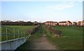
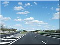
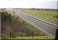
3
Footpath under Bedford bypass looking South
Image: © d brewerton
Taken: Unknown
0.16 miles
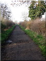
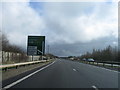
6
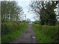
Public Bridleway
A public bridleway running between Bunyan's & College Farms. In the distance you can see works going on to the A421 underpass.
Image: © Mr Biz
Taken: 24 Apr 2008
0.21 miles