IMAGES TAKEN NEAR TO
Barkers Lane, BEDFORD, MK41 9SD
Introduction
This page details the photographs taken nearby to Barkers Lane, MK41 9SD by members of the Geograph project.
The Geograph project started in 2005 with the aim of publishing, organising and preserving representative images for every square kilometre of Great Britain, Ireland and the Isle of Man.

There are currently over 7.5m images from over14,400 individuals and you can help contribute to the project by visiting https://www.geograph.org.uk
Image Map
Images are licensed for reuse under creativecommons.org/licenses/by-sa/2.0
Notes
- Clicking on the map will re-center to the selected point.
- The higher the marker number, the further away the image location is from the centre of the postcode.
Image Listing (29 Images Found)
Images are licensed for reuse under creativecommons.org/licenses/by-sa/2.0
Image
Details
Distance
1
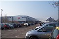
Car Park
This is the car park to Aspects leisure Centre. Home to redundant leisure outlets, a cinema and a gym. The people of Bedford were given all this in place of a very fine open air swimming pool.
Image: © Dennis simpson
Taken: 13 Feb 2008
0.08 miles
2
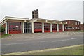
Bedford fire station
Bedford fire station, Barkers Lane, Bedford, Bedfordshire
Image: © Kevin Hale
Taken: 7 Oct 2007
0.10 miles
4
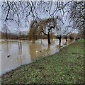
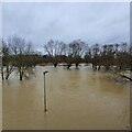
The Great Ouse in Flood - Boxing Day 2020
Looking west, upstream, from near the footbridge at the junction of Longholme Way and the Embankment. Quite a lot of people out looking, and hoping it won't go much higher.
Image: © Duncan Richardson
Taken: 26 Dec 2020
0.14 miles
5
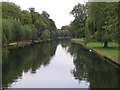
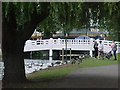
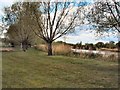
The River Great Ouse
A view downstream from the Butterfly Bridge.
Image: © M J Richardson
Taken: 9 Sep 2007
0.14 miles
6
Bedford's river Great Ouse
From the Bedford-Sandy cycleway (previously the Bedford-Cambridge railway line)
Image: © Oliver White
Taken: 2 Dec 2006
0.15 miles
7
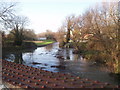
Up periscope?
Submerged path, with light, by one stream of the River Great Ouse and adjacent Boating Lake, as seen from Longholme Bridge, after extensive flooding on Boxing Day.
Image: © Duncan Richardson
Taken: 26 Dec 2020
0.15 miles
8
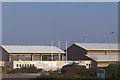
Bedford International Athletics Stadium
Now the home to major athletic events. Earlier in its career it only seemed to be used by the local schools!
Image: © Dennis simpson
Taken: 13 Feb 2008
0.16 miles
10
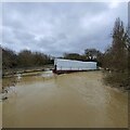
The Great Ouse in flood
The King's Bridge under repair https://www.bedfordindependent.co.uk/kings-bridge-to-close-for-refurbishment/ overtaken by events. Anticipated to take 6 months, I expect it will now take a lot longer, after being inundated by the Boxing Day flood. At first I thought it was a curtain trailer that had relied on GPS.
Image: © Duncxan Richardson
Taken: 26 Dec 2020
0.18 miles