IMAGES TAKEN NEAR TO
Greyfriars, BEDFORD, MK40 1HP
Introduction
This page details the photographs taken nearby to Greyfriars, MK40 1HP by members of the Geograph project.
The Geograph project started in 2005 with the aim of publishing, organising and preserving representative images for every square kilometre of Great Britain, Ireland and the Isle of Man.

There are currently over 7.5m images from over14,400 individuals and you can help contribute to the project by visiting https://www.geograph.org.uk
Image Map
Images are licensed for reuse under creativecommons.org/licenses/by-sa/2.0
Notes
- Clicking on the map will re-center to the selected point.
- The higher the marker number, the further away the image location is from the centre of the postcode.
Image Listing (338 Images Found)
Images are licensed for reuse under creativecommons.org/licenses/by-sa/2.0
Image
Details
Distance
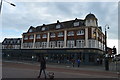
1
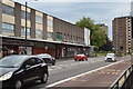
Greyfriars, Bedford
Looking north from the junction with Midland Road.
The far end of the building on the left originally housed a Safeway supermarket, opened in the 1960's.
Image: © Rich Tea
Taken: 19 Jun 2009
0.01 miles

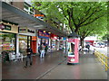
8
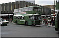
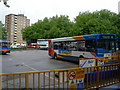
Midland Road
United Counties 607 travelling along Midland Road, in the direction of the railway station, crosses River Street on route to Mowsbury. The pavements are full of Saturday shoppers. 607 is a Leyland Olympian.
Image: © Martin Addison
Taken: Unknown
0.04 miles